2016-10-26 42 -78
| Wed 26 Oct 2016 in 42,-78: 42.6049371, -78.0029735 geohashing.info google osm bing/os kml crox |
Location
In the woods of Letchworth State park on the Eastern side.
Participants
- Pedalpusher
- Simon the dog
- Myka the dog
Expedition
It was a bit of an emotional day for me. Back at the end of May, I found out that many positions where I work would be eliminated and I was going to be affected. Some people only got 30 or 60 days, but luckily, I got almost 6 months. I've spent that time looking internally for a position, but nothing came of that. Today, I wrapped up the remainder of my work to hand off to my co-workers and went to one of their houses to drop off my equipment(we all mostly work from home). Met another co-worked there and we chatted and had lunch before saying our final work good byes.
Getting home a bit after 15:00, I saw that today's hash not only landed in a State park, but it looked accessible AND more importantly, fell in that tiny sliver of land in Livingston County within the Buffalo Graticule. I packed up the dogs, wrote out directions and drove to Letchworth. I also saw that there was a Geocache very close to the hash and that the cache was accessible from the Park Road that went by.
Knowing that it's hunting season, even though it was Thursday and likely very few people would be out if any, I decided to park not as far down the road as I could have and walk on the road(rather than going for a hike in the woods after). I found a larger parking area off the road about 1.5 miles away and thought that was about perfect to still have enough time to get back before dark.
Hopping out, the dogs were very happy to run around and being on the smaller and less popular side after camping season, I didn't have to worry too much about cars. On our walk, I saw a number of hawks and even a Pileated Woodpecker.
Getting close to the hash, I saw I was approaching a very large ridge and the road also started to head up. Of course the hash is going to be at the top of the STEEP hill, but I kind of expected it since the geocache that's close is called 'Huff and Puff'(for a good reason). As I walked up the road, I decided rather than go straight to the hash, I'd go a little further and walk up the...I don't know what you call it...the nose of the ridge? It's a bit less steep that way rather than walking directly up the side or even trying to 'reverse slalom' up the incline.
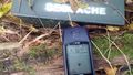
Getting to the top of the ridge, I walked along until I was as close as I could be and unhappily noted it was about 40 feet down the steeper side from the top. Carefully sliding down using trees to stop and pause(I didn't want to do a big GPS dance and overshoot), I slowly worked my way to zero in on the hash, but not quite getting there exactly. I got my pictures, and worked my way back up to the top and over the other side into kind of a bowl the ridges made to find the geocache. My GPS connection was a bit spotty there and it took a minute to locate the geocache, but I got it for another Honorable Mention Hash Collision.
We then made our way back to the road and eventually the car just as it was starting to get dark. A great expedition overall...until we got home that is. I ended up pulling 10 ticks off of Simon and just one off Myka. I thought maybe they didn't like her short fur as much before remembering that she had her pink coat on because it was a little chilly. Looked that over and found another 5. Bloodsucking bastards!
To commemorate another step closer to my Reverse Regional Ribbon by county, I'll also issue a Tale of Two Challenge for Livingston.
Photos
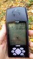
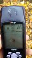
Made it.
Accuracy.
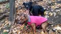
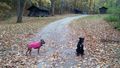
The dogs carefully sitting at the hash and trying not to slide. Their backs are level with their straight front paws as they are sitting on the hill. It was very steep where we were.

Happy to get there.
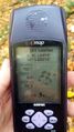
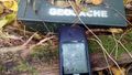
For the Hash Collision, the distance from the hash to the cache.
Found the cache!
The distance back to the hash. The reception was poor in this area so that's why there is a difference.
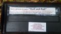
The inside of the cache. It certainly took some huffing and puffing to get up to the top of the ridge.
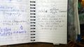
I signed the log. "The Internet was here"
On the way back, we decided to walk by the cabin loop off the main road we were walking on.
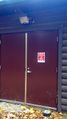
By the cabins was this large building with a dire warning. It's hard to read, but it says: "WARNING! Tampering with this facility is a FEDERAL OFFENSE".


Ribbons
This user earned the Land geohash achievement
|
Pedalpusher earned the Hash collision honorable mention
|
Pedalpusher issued a challenge for the Tale of Two Hashes achievement
|