2016-10-30 47 11
| Sun 30 Oct 2016 in 47,11: 47.9777143, 11.4175204 geohashing.info google osm bing/os kml crox |
Contents
[hide]Location
The geohash is in a forest near Ebenhausen.
Who Went
TheOneRing - by car.
The Expedition
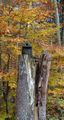
Today was nice weather and I decided not only to go geohashing but also to walk a bit. Closest village (or small city) to the geohash was Ebenhausen with approx. 2.5km to the geohash as the bird flies. I parked on a parking lot at the train station and started my tour. First, my way led me to a housing area, then over a field before reaching the forest. The forest tracks were still in good shape despite of the occasional rain in the last couple of days.
Inside the forest, I had several possibilities to walk and I chose the correct one (which does not happen very often): In the end, there were two forest tracks leading to the geohash and I chose the one going up a hill. If I had chosen the other one, I would have been stuck on a much stepper hill with moss on the ground. Slippery and not recommended.
I took the usual photographs and thought about going back. As I said, the weather was nice, so I decided to extend my tour and walk further to the forest, in direction of Irschenhausen. That village is a little bit South of Ebenhausen, so I arrived eventually at my car, but with more walking.
I failed finding something decent to eat, so I drove to the next bigger city, Wolfratshausen, and some coffee there.
Photos
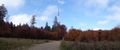
Panoramic view of the forest near the geohash with a wind generator
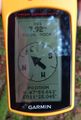
Coordinates reached
Here it is
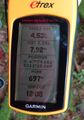
Some more infos

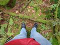
Stupid grin
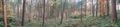
Panoramic view over the geohash...yeah it's a forest

Different wind generator and a bridge over the autobahn
A small aviary


Achievements
TheOneRing earned the Land geohash achievement
|