2016-12-29 49 8

| Thu 29 Dec 2016 in 49,8: 49.1366193, 8.0196567 geohashing.info google osm bing/os kml crox |
Location
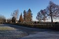
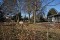
A fresh vineyard next to the graveyard in Klingenmünster.
Participants
Plans
The lady has to work today but I have the day off so I can try to go there on my bull in the early morning not crossing my own path.
Expedition
I started at 8:20The sky was blue but the sun was just rising and it was very cold. I've seen that the hash is near the graveyard (although it's not at the graveyard, no holy hash :-( ) and I saw that I would come along a former jewish graveyard to so I decided that I would stop at every graveyard that I would come along. After 45 minutes I reached the first one in Bellheim (now I see that I also passed the graveyard in Westheim but I missed that during the ride). Just 15 minutes later the former jewish cemetery of Rülzheim was situated next to my street. Next I came to Herxheim but didn't find a cemetery there. I've seen on the map that the bicycle path makes a circle when it crosses the highway A65, so I switched to the road before I reached the crossing (to be honest, I'm not even allowed to use bicycle patches with the bull, but every car that overtakes me thinks I'd had to and so i mostly use them anyway, as long as they are appropriate).
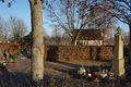
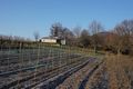
Then I came through Rohrbach and Billigheim; in the latter I found another graveyard. And a short time later, before I reached Heuchelheim I had to stop again for a photo because the cemetery was situated just next to the road.The next village was already Klingenmünster and so I was sure that there won't be anymore dead people on my way to the hash. The hash was situated over a steep vineyard, that laid just above the village. I followed a street next to the vineyard and then reached a path that ran above it.
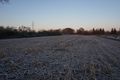
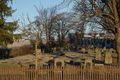
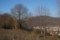
After 200 meters I left the bull and walked a little bit further up, the last 60 meters to the hash must be taken by foot. I found a very fresh installed vineyard, just some sticks in the earth. A free wasteland in front of it made it very easy to reach the hashpoint. I had a good view to the chapel of the nearby cemetery - number five today. I might have crossed my own path on my way back to the bull, but you can hardly avoid that when you're hashing with a bike and the hash isn't just on a street, and I guess, the rules allow hash dancing.I continued my ride. The path leads to a street that ran below the graveyard, but as that was on the top of a hill, I didn't get a better view to it than from the hash itself.
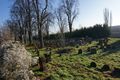
From Klingenmünster I had to ride to Landau. To my surprise there were several steep hills between those two towns and it was way more exhausting than I had expected. Maybe because of that - or because I was just on a downhill I didn't remark the big cemetery of Landau at my left side. But after I've crossed the little village of Essingen I found a second former jewish cemetery just next to my path. And at Harthausen, the seventh and last graveyard on my way was documented. I didn't expect to find that many of them. Maybe I should propose an achievement - graveyards along the way to the hash - and levels that gets the counts of documented ones).
I rechen home at 12:15 again after a very nice and exhausting ride.
Tracklog
Photos
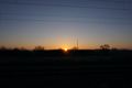
the sun was just rising...
and it was very cold.

cemetery in Bellheim...
jewish cemetery in Rülzheim (well, outside Rülzheim to be honest)
the ones in Billigheim and ....
before Heuchelheim
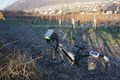
finally I locked my bull (proof of transport)
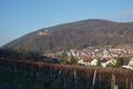
at a place with a great view over Klingenmünster to the castle Madenburg
proof
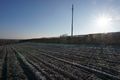
a new vineyard
the chapel of the cemetery seen from the hash
the hashs view to the Madenburg wasn't as good as the bulls one

happy hasher
on my way back I found the jewish cemetery of Essingen
and the graveyard in Harthausen


Achievements
DODO earned the Land geohash achievement
|
DODO earned the Tron achievement
|