2017-02-11 38 -90
| Sat 11 Feb 2017 in 38,-90: 38.0267686, -90.1390999 geohashing.info google osm bing/os kml crox |
Location
The meetup point is deep in the woods off the trail in Magnolia Hollow Conservation Area, a beautiful and heavily wooded piece of public land on dissected bluffs overlooking the Mississippi River north of historic Ste. Genevieve. There is a private inholding that needs to be avoided on the way to & from the meetup point. Consult this PDF map from the Conservation Department.
Participants
- Kbh3rd and
- his lovely bride.
Plans
I and my wife may shoot for arriving at the meetup point at about 3:00 pm if we follow through on these preliminary plans. (Or at any other time, who knows?)
There will be some bushwhacking involved since the point is well off any trail. After looking at the map and examining the area in QGIS, I think the best route is to start along the access trail that runs south from the northwest corner of the area near where the main road enters the property. About 1.13 miles in, after turning east and dropping about 150 ft, the trail crosses a creek bed. If we leave the trail at that point and head east down the stream for about 0.2 miles it will take us close to the southwest corner of the private inholding. Turning south and going up the hill for about 540 ft should bring us right to the meetup point. Total distance in would be close to 1.5 miles, or 3 miles round trip.
It's entirely possible that we'll decide it's a nice day for a hike, but not that long of a hike. We'll see. -- Kbh3rd (talk) 04:29, 11 February 2017 (UTC)
Expedition
What a beautiful day for a hike! The temperature this February day was about 75° F (24° C) with scattered sunlight and clouds. The hike went exactly to plan. The GPS says it was 2.9 miles round trip, and we were at the meetup point at 3:00 pm as planned. (Where were you?!) The area was very rugged and wild and very cool. The trail, which on the hilltops and ridge tops is more of a jeep trail, appears to continue straight where the map shows it turning to the east by a wildlife waterhole. Because we had the landmark of that waterhole we did not miss the turn and managed to keep on the proper route. It's much more of a footpath as it heads down the hill towards the creek.
The hills are a lot steeper than they appear on the topo maps! The creek fortunately was dry, though it looks like it sometimes gets a lot of water. If you look at the satellite view of the meetup point, you'll notice that it's in an area where the forest looks lower & thinner. For some reason there are no large trees right in this area. That means that it's fully overgrown with underbrush, making navigation and movement right at the point very difficult. It would have been nigh well impossible with full foliage, not to mention ticks & chiggers. This was the right time of year for this.
I found a broken cart wheel of some sort on the trail on the way out. I carried it out, as testified by the picture below. My guess is that it came from a hunter's game cart, as these conservation areas are not parks and are open to hunting. I was wondering whether anyone would consider the Geohashing calling card that I left to be trash. This wheel was much larger and much heavier than that, so I think I've got positive karma in the litter department on this expedition.
After hiking to and from the meetup point we went up to the platform that overlooks the Mississippi River where Establishment creek flows into the river. It was a beautiful afternoon, and I hope the picture below captures some of the subtle beauty of the scene.
Photos

Elevation profile for the hike from the phone GPS
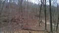
Where we left the trail to follow the creek.
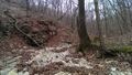
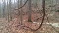
In the creek bed in the bottom of a steep little valley
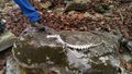
Part of the skeleton of some sort of creature found on a rock in the creek bed.
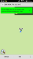
The proof.
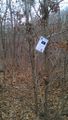
"The Internet was here." Printed half size and laminated against the weather.
5-inch diameter (13cm) wild grape vine.

Busted cart wheel found in the woods and removed as trash.
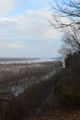
Magnolia Hollow Conservation Area viewing platform overlooking Establishment Creek and the Mississippi River.
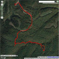
GPS track with a pin on the car. The meetup point is at the lower right end of the track.


Achievements
- Land Geohash