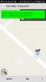
2017-02-14 -37 145
| Tue 14 Feb 2017 in -37,145: -37.8491212, 145.4526681 geohashing.info google osm bing/os kml crox |
Location
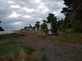
On a steep slope on a road in the country east of Monbulk
Participants
Kozz (talk) 05:24, 18 February 2017 (UTC)
Plans
I spotted this on valentines day but didn't have the three hours to ride out and back.
Expedition
I spotted this on Wednesday but didn't have time to ride put in the morning and would've passed out at my desk by midday as it's an 80 km round trip.
I left home, stopped about six times to adjust my cleats then took Canterbury Road to the Dandenong Ranges then through Mount Evelyn (missed a golden opportunity for innuendo; 'I'm going to mount Evelyn on Valentines day').
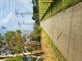
Rode through the back of Silvan where it promptly started to drizzle heavily. It was pre dawn too so not overly pleasant. I found the Seville road turnoff and got to Hollis road turn off.
The hashpoint was just after the apex of a hill and on a steep slope, I got to it, snapped the pics and thought I'd just ride on. Big mistake, the road turned into gravel 1.2km later and I had to slog my way back up the same hill. Ironically I could've kept going and ended up at today's hashpoint - it was 17km from this one- but that would be pushed us put to at least 120km which is far beyond my current fitness. Another time.
I rode back through Belgrave and Ferntree Gully before the Eastland trail.
Tracklog
Photos
I made it!

En route

Hash point approach hill

The hashpoint (potato quality)

Hill on which the hashpoint lies
Farms
Sunny day finally


