2017-04-02 49 11

| Sun 2 Apr 2017 in 49,11: 49.9407021, 11.0263431 geohashing.info google osm bing/os kml crox |
Location
forest near Kremmelsdorf, Bavaria, Germany
Participants
- Klaus
- his brother
his father
Plans
I was staying at my parents and sitting on the couch on sunday noon, when I noticed that there is a quite close hash. As the weather was really fine, and my father wanted to do a bicycle tour anyway, we decided to start soon.
Expedition
We left at around 15:15 with two electric pedelecs and a normal bicycle. As the hash was down in the valley, the original plan was that our father would take the conventional bicycle and only drive the part without hills with us. Unfortunately, we noticed after a few kilometers, that one of the pedelecs lost air. So my dad took this one, went back sooner than expected and my brother decided to do it nevertheless with the conventional bicycle - even when this required to drive down the "Tiefenellerner Berg".
Our whole tour was unspectacular and brought us through the following villages: Hohenpoelz -> Laibaroes -> Tiefenellern -> Lohndorf -> Litzendorf -> Schammelsdorf -> Kremmeldorf -> Geohash -> Peulendorf -> Puenzendorf --(f*cking steep hill)-> -> Neudorf -> Laitaroes -> Hohenpoelz
The Puenzental valley is very beautiful and offers a nice view to the iconic ruins "Giechburg" and the church "Guegel" which is build on a rock.
Photos
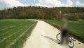
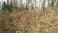
approaching the "target forest"
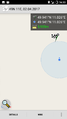
Proof
Proof Transportation
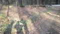
Geohash View #1
Geohash View #2
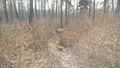
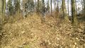
Geohash View #3
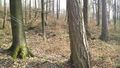
Geohash View #4
- Error creating thumbnail: Unable to save thumbnail to destination
Giechburg und Guegel on the way back


Achievements
Klaus earned the Land geohash achievement
|
Klaus earned the Bicycle geohash achievement
|