2017-06-01 42 -78
| Thu 1 Jun 2017 in 42,-78: 42.7260384, -78.2655076 geohashing.info google osm bing/os kml crox |
Contents
[hide]Location
Orangeville Center, NY in the woods
Participants
- Pedalpusher
- Simon the dog
- Myka the dog
Expedition
Checking the hash at work in the morning I got excited as I zoomed it as it was close to a Summer Camp I used to work at as well as a cottage of my parent's friend. Zooming in further...and what's this? It's in the block where the cottage is and almost directly North of the property! Sweet, I'm definitely going after work! Getting home, I quickly changed, got the dogs ready and we were off.
Pulling into the property, I checked the house to make sure everything was looking normal while the dogs ran into and around the pond. Then we headed for the woods and the hash. I walked down the really old logging trail to the back of the property and in the direction of Wyoming Hills, a sort of cottages-in-the-woods 'neighborhood'. Skirting those cottages, I walked past the 'Cinderblock house' which in reality was a shed housing a small radio tower's equipment(but we use it as a landmark when we are out there hiking or hunting). Pushing off the established paths, we headed into a very swampy area. Most of the middle of this block is a big swamp, but today I was glad it's been a bit dry. I would have had a much tougher time otherwise.
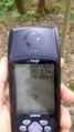
The closer we got, the mushier the ground got, eventually turning into tons of small islands of firm ground. As I approached 100 feet/30 meters, I got a bit stuck with large pools of water all between me and the direction I wanted to go. I difficultly climbed over downed trees to the left and made a huge detour. It was at this time that I wasn't paying attention to the GPS, just trying to get through to the next island and it made a funny noise. I looked down and saw it was off. Hoping I just accidentally hit the off button, I turned it back on. Signal back, and ready to continue, but...why am I now 90 miles from the hash when I should be really close? Checking the coords, they were accurate. Turn off and on again. Shake it. Still saying 90 miles away. I get out my phone and start up HashDroid but I'm down to 1 bar and can't get a location. Arg! Back to the GPS, I check the coords again and they are still accurate and out of desperation, I hit the GoTo button again. In climbing over stuff with the GPS in my hand, I must have been hitting buttons and changed the point I was going toward. Whew! I eventually zeroed in on the hash and did a short dance to get close enough.
Starting to head back, I looked across the nearest pool and recognized the initial tree that I climbed over. Doh! If I had only gone to the right, it would have been SO much easier. Heading back that way, I found my way back to the Concrete House and from there to the cottage.
Photos
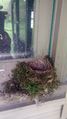
At the cottage, I found a bird had built a nest on one of the windowsills.
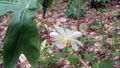
On the way to the hash, I saw the Mayapples are in bloom. I didn't realize they grow from one root. A poisonous plant, but you can eat the fruit once it turns yellow.
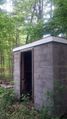
The 'Cinderblock house' and our landmark.
Made it after some difficulty.
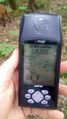
Accuracy.
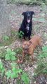
The dogs sitting patiently for their picture.
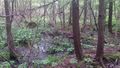
A view of the area around the hash.

Relieved to make it; with dry feet too.
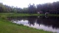
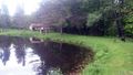
Back at the cottage, a view across the pond.
The dogs like to zoom around as I walk back.


Ribbons
This user earned the Land geohash achievement
|