2017-07-16 62 29
| Sun 16 Jul 2017 in 62,29: 62.8192469, 29.8218976 geohashing.info google osm bing/os kml crox |
Location
In the forest in a place called Kukkoliete (what a strange name, "Rooster Sludge" would be the literal translation, but in Finnish the name doesn't mean anything, either). Varparanta village, the municipality of Kontiolahti.
Participants
Expedition

A quick hashpoint-grab on our way from Pastori's place to our home. After some twists and turns to find the right road, we parked about 150 m from the hashpoint, and I embarked on a quick stroll through the forest. My Daughter was so hot and tired she didn't want to join the expedition, and there would probably be a lot of mosquitoes, too. And there was! They didn't keep up with me as I jogged to the hashpoint, but immediately after I had stopped to the actual hashpoint, they attacked with numbers. I could slam at least half a dozen from my calves with a single stroke at any given time. Despite the interference, I managed to get a picture of my stupid grin and the coordinates, accuracy 1 meters. Then quickly back to the car and towards home!

Photos
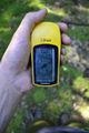
GPS proof.

Achievements
Tilley earned the Land geohash achievement
|