2017-07-21 51 9
| Fri 21 Jul 2017 in 51,9: 51.1378969, 9.3458514 geohashing.info google osm bing/os kml crox |
Location
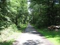
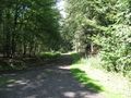
The hash of today lay in the middle of the Oberstes Holz, a small forest between Felsberg and Fritzlar.
Participants
Plans
Today was a special day for me. The Federal Ministry of Transport and Digital Infrastructure in Germany and the infas Institut für angewandte Sozialwissenschaft — institute for applied social science carry out a study Mobility in Germany. And they picked me out for reference. And today was the day of report. I shall note all my today's ways and send the result to them.
So I thought, is there something, which is a normal mode of transport for me, which I can write down into such a study. And what do I do around, specially here? Hitchhiking. So I decided for today, I have to hitchhike. And where is the best place to go for on such a day? Of course, geohashing! So for today I had two jobs: hitchhiking first, geohashing second.
Report 1
 |
 |
It was a usual hitchhiking. I left home, bought on the run an orange soda, wrote a sign, waited for half an hour and with one car I arrived there out at the national road in the height of the forest Oberstes Holz. |
 |
 |
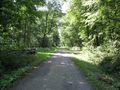
On the way into the forest I saw this barrier. I went to it for a look. And from my side it was clear. But from the other? |
 |
 |
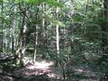
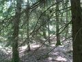
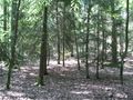
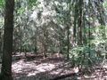
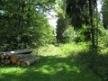
The direct way was full of stinging nettles and I made a detour on other ways and then, near the geohash only 50 meters away and looking for the entrance into the thicket, I found this sign. Attacks of birds of prey! In the southwestern edge of the forest. The geohash lay in the northwestern edge, but on the way home I wanted to walk through this area. The geohash was easy to find, nothing spectacular. |
 |
 |
Then I walked to the northern side of the forest. There, in the fields, I saw a big orange-brown bird starting from a post. And I went to this post for a look. |
 |
And while standing at this post, looking and taking photos, I heard this bird. And it cried. And it was not the usual cry. The bird flew across the northern end of the forest in circles and cried: cree - cree - cree - cree. But as I went away from the post it changed to the normal cry: creeeeh — creeeeh — creeeeh — creeeeh. And I thought about what would have happend to me if the today's hash was in this northeastern end of the forest? | |
 |
After this adventure I went down to Cappel, the village to which this forest belongs, and to Niedermöllrich, from where I hitchhiked home, this time with two cars. | |
 |
In the evening I made an excursion to the airport. During the documenta the transport authority of Kassel decided to create an hourly bus service to the airport, also during the night. Nothing to do with geohashing, but something to do with public transport and my sorts of using it. |
Report 2
| start time | reason | mode of transport | distance | destination | arrival time |
|---|---|---|---|---|---|
| 9:33 | shopping | on foot, tram, tram, on foot | 5.5 | Kassel, Frankfurter Straße 128 | 10:05 |
| 10:10 | journey | on foot, hitchhiking | 21.5 | national road B254, Abschnitt 023, km 2,4 | 11:12 |
| 11:22 | hiking | on foot | 2.5 | 2017-07-21 51 9, Oberstes Holz, Cappel | 12:00 |
| 12:28 | hiking | on foot | 4.8 | Niedermöllrich | 14:18 |
| 14:18 | travelling home | hitchhiking, hitchhiking, on foot | 24.6 | Kassel, tram stop Am Weinberg | 15:10 |
| 15:10 | shopping | bus, on foot | 2.1 | Kassel, Wittrockstraße 29a | 15:25 |
| 15:45 | going home | on foot, tram, on foot | 6.2 | Kassel, tram stop Arnimstraße | 16:06 |
| 23:40 | leasure | on foot, tram | 7.2 | Kassel-Wilhelmshöhe, railway station | 0:14 |
| 0:33 | leasure | bus | 19.2 | Calden, Airport Kassel | 1:12 |
| 1:35 | going home | bus, bus, on foot | 21.7 | Kassel, tram stop Arnimstraße | 2:35 |
They didn't have Niedermöllrich in their database. The database doesn't know the airport in Calden and not the Fieseler-Storch-Straße. And the day of report is not my day between rising in the morning and going to sleep sometimes later, they ask for the 24h-day. In their logo, there are neither hitchhikers nor geohashers to see. https://mid.infas-online.de/q1/media/MiD/mid_logo.png
Report 3
And not to forget:

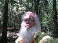
proof
north
east
south
west
Georg Der Reisende
north
east
south
west


Achievements
GeorgDerReisende earned the Thumbs Up Geohash Achievement
|