2017-08-05 67 24
| Sat 5 Aug 2017 in 67,24: 67.5327826, 24.2276548 geohashing.info google osm bing/os kml crox |
Location
Ylläs [1], Tail end of the fell. Off up the hill on the side of the scenery route around Ylläs. The point lies on a lower part of the hill in a forest.
Participants
- Pastori
- The Wife
Expedition

On the day they were set to leave back home from their week at Ylläs Pastori noticed there was a hashpoint in a graticule he had not yet visited. The point was near the beginning of their journey, only about 10km of driving. The 900 m from the road to the point looked like it was going to be hard to traverse, with its big rocks but Pastori and Wife are nothing if not tenacious so they gave it a go.
After about 200 m on a hiking trail the going did indeed get quite difficult but slow and steady, surrounded by mosquitoes and after shedding quite a few sweat drops they did manage to reach the point with an accuracy of 0.906 m.
After the mandatory pictures, Pastori decided to take a different route back. Wife pointed out that there was a rather deep ravine that they had to climb down to as well as its equally steep other side to go up! They made it to the bottom of the ravine just fine and managed to get over the bit of water that was on the bottom by crossing over some felled trees but then steep hill up! Pastori engaged in some tactical pushing and with Wife using her hands and legs they did indeed manage to get up from the ravine and back onto the hiking trail and onward easily back to the car.
The trip took 1.5 h and 2.5 km. Difficulty level on a scale of 1 to 5, Pastori says 4 but Wife says 5++. Thankfully it was only mid-morning and they continued onward to the next hashpoint while snacking. The next graticule was also one Pastori had never visited before.


Photos
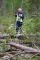
Pastori and the point.
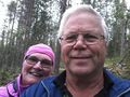
Selfie!

GPS proof.


Achievements
Pastori earned the Land geohash achievement
|
Pastori achieved level 7 of the Minesweeper Geohash achievement
|