2017-08-06 42 -85

| Sun 6 Aug 2017 in 42,-85: 42.6016806, -85.7434103 geohashing.info google osm bing/os kml crox |
Location
meadow at Jijak Camp, property of the Gun Lake Pottawatomi Indian tribe, Hopkins, MI, USA
Participants
Expedition
I left 2017-08-05_42_-86 about 8:15 pm. It wasn't clear to me whether this hashpoint would be accessible, so I wanted to have a look before it got dark.
The camp, just south of the little town of Hopkins, MI, was formerly a summer camp owned by a West Michigan Christian charity. In 2010 it was purchased by the Gun Lake Pottawatomi tribe, presumably with money made at the nearby Gun Lake Casino that they own. It is now the Jijak Camp, a tribal history and cultural center, and seems to have a particular focus on indigenous agriculture. The Spring 2017 Great Lakes Intertribal Food Summit was held here.
I arrived around 9:10. The driveway was open, and a short drive brought me to a gravel parking lot near the main buildings. I was looking for "No admittance" or similar signs, not wanting to be disrespectful, but I saw none at all; I appeared to be welcome. No other cars were in the lot and I did not see anyone else. As I walked through the lot making trying to understand where the hashpoint was, a bunch of lights came on throughout the camp, and I wondered whether I had tripped a motion sensor, but I decided they simply came on at dusk.
A short walk along a gravel road brought me to the edge of a field; a left turn into a meadow, over a rise, through a swale, and to the top of the next rise, brought me to the Sunday hashpoint at about 9:30 on Saturday.
A full moon was coming up and it didn't look like this trip would be hard to repeat at midnight. So I returned to the car and drove roughly two miles back to Hopkins. The town appeared to have two bars, one on the main street and one on a side street; I chose the main-street one because it looked more likely to have food.
I had a Viking Burger (cheese, grilled onions, Thousand Island dressing; not very Scandinavian, but the high school teams here are the Vikings and I expect it's a local thing) and a couple of beers, and watched the Baltimore-Detroit baseball game (Tigers lost 5-2) and the karaoke exploits of a group of women of various ages who were all there together. The place was lively and upbeat but not crowded. Unfortunately this doesn't count as a Pub Hash because the pub was not within sight of the hashpoint.
I returned to the camp and started once again for the hashpoint about twenty minutes before midnight. The grounds lights were still on, so the walk along the gravel road was not difficult. Once in the meadow, after my eyes adjusted, the moonlight was plenty for walking, and I returned to the hashpoint without a problem. By now I was quite worried that my phone/GPS battery would be dead before I got the proof-shot, so I left the device off until I was back to the hashpoint. I had to wait around a few minutes for midnight, and the GPS had changed its mind slightly about exactly where the hashpoint was, but the batteries held out and I got a nice midnight proof-shot.
On the way out I stopped to try to photograph the totem poles at the entrance.
I'm claiming the bonus points for reaching this Midnight Geohash without bringing my own light source. I don't think this counts as a "midnight double", since the previous expedition 2017-08-05_42_-86 was in daylight.
Edit, 2018-04-28: apparently this expedition earns Last Man Standing.
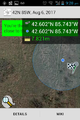
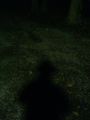
Proof-shot from reconnaisance expedition a few hours before midnight.
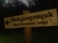
Sign at parking lot pointing along gravel road that leads to hashpoint.
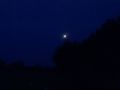
Natural light source, seen from hashpoint on second expedition.
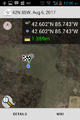
Proof, of location and time. Notice low-battery warning.

Grin. Please don't examine carefully; the redeye is quite bad.
Alternative Stupid Grin, much less redeye.

Sign at entrance to camp.


Achievements
George earned the Midnight Geohash achievement
|
George earned the Last Man standing achievement
|