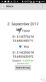
2017-09-02 51 13
| Sat 2 Sep 2017 in Dresden: 51.1140776, 13.6403481 geohashing.info google osm bing/os kml crox |
Location
Location
The hash is located at Obere Bergstraße in Radebeul-Niederlößnitz. From the map it should be accessible.
Country: Germany; state: Sachsen (Saxony, EU:DE:SN); district: Meißen; municipality: Radebeul
Weather: mostly clouded
Participants
Plans
- Oisín plans to visit this hash in the afternoon. He'll be on his way to a Geocaching Event.
- Danatar saw the coordinates and planned to be there at 4 p.m. He didn't check the wiki for other people's plans, else he would have tried to coordinate with Oisín.
Expedition
Oisín
I left home at around 3 p.m. First I cycled to one of our DIY markets as I had some small items on my shopping list. Then I continued my way diagonally through Radebeul to the Obere Bergstraße. Finally, at around 4:30pm the hash point was reached. The hash point lies between parking cars on a slope directly beside the road. After taking some pictures at the location I continued to the planeterium for an interesting presentation and nice talks around a camp fire.
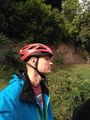
Oisín at the hash point
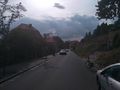
Looking westwards
Stargazers at the planetarium
Screenshot from GeoHash Droid app


Oisín earned the Bicycle geohash achievement
|
Danatar
I started my cycle tour to the hashpoint a bit later than planned, shortly after 3 p.m. After reaching the Elbradweg (Elbe cycle route) I followed that one to Mickten, then I went along the flood control channel, made a detour around the Autobahn and returned to the track that ran along the Elbe. At Radebeul-Kötzschenbroda the track ended and I cycled uphill until I reached Obere Bergstraße right before 4 p.m. The hashpoint was easy to find, it was on the side of the road and I didn't even have to step into the grass (in contrast to the satellite image). After taking pictures I started the return trip. Because of my excellent preparation I didn't know that Oisín was also planning to visit the hash. I'm not sure if I would have waited long enough to meet him though, because he didn't give a time. On the way back I took a different route but it did not lead me back to the Elbe until I was back at Mickten.
In total I cycled 31.5 km.
|


