2017-12-17 42 -78
| Sun 17 Dec 2017 in 42,-78: 42.0008385, -78.8250286 geohashing.info google osm bing/os kml crox |
Contents
[hide]Location
Allegany State Park, off the North Country Trail by Pennsylvania
Participants
- Pedalpusher
- Simon the dog
- Myka the dog
Expedition
Let me just start by saying this is definitely one of my Top Favorite expeditions.
On Friday, my initial thought was, oh look another ASP expedition! I think about 10% of my expeditions have occurred in or around Allegany in the Buffalo Graticule. It's only a matter of time before I get an expedition Deja Vu, but this one wasn't close to anything.
Sunday Morning, I was considering my options and was concerned about how much snow there would be out there. I've gotten about a meter of snow over the past week and a half or so, but I'm more in the snow-belt. Checking out a NOAA map I found online, they had the snow depth around less than half of that in and around Allegany. Still not bad, but I thought renting snow shoes would be wise. I looked at the ASP website, but turns out they don't rent snow shoes any longer. I found a place in Ellicottville, which is on the way, with decent prices and planned to stop there. However, they close at 16:00 on Sundays so I would actually have to be leaving the house around 11:00 to have enough time to get back to the shop when I was done.
Dressing in layers, packing a lunch and snacks, and getting the dogs ready, we were in the car mostly on time. As we were driving down, I monitored the snow depth in people's driveways and thought I could probably get away without snow shoes, but I decided to stop anyway. I've never really used them before in decently deep snow.
The shop was very friendly and I requested shoes but no poles(I had grabbed my own ski poles from home). Talking with the people, I let them know that I just wanted them for today (even though it was a 24 hour rental), and was planning on dropping them off on my way home before they closed. The lady processing my rental was saying that the owner lived above the shop and they didn't want me to have to rush back. She said if I got back after 16:00, I could drop off the shoes in the stairway behind the shop and they would get them in the morning. How cool is that?
I thanked them and we were back on our way. Getting to Allegany, I had a few options from my initial satellite/map look-over. I could park near one of the maintenance areas off Coon Run Road where another cabin loop branched off. This would probably be the fastest and easiest as I could walk up the road to the North Country trail. I pulled in there initially, but thinking about the extra time I was given with the rental, I decided to extend the hike and went a little further up the road. I parked at one of the parking areas for the N. Country trail and started toward the hash. It was an absolutely beautiful day. The temps were in the upper 20's (F), little wind and the snow was nicely covering everything.
I did have to be careful though as the deer hunting season was still ongoing (last day I think) and there was a truck parked where I was. Fortunately, the footprints broke off the trail pretty quickly and went off into the woods away from where I was going. I figured once I got a bit into the woods, I wouldn't have to worry about hunters. The further you go into the woods, the further you have to bring something back and deer can be pretty heavy.
The North Country trail is part of the Finger Lakes Trail and goes throughout New York State so there are shelters and signs all along the trail. Getting to a section by the road, there was a sign indicating it was 2.2 miles to Coon Run Road, a half mile to the next shelter the other way and (without a distance) the Catskills, which are well past the Finger Lakes in the middle of the state, closer to New York City.
Walking down the path, I could see someone had been there a while ago, but new snow had mostly filled in their tracks. I crossed a few streams, passed by a group of cabins I could see from the path and saw a ton of animal tracks. There were mostly deer and mice tracks. The mice were interesting because you could see where they popped up from the snow, ran around for a while on top, and then dove back down under the snow again.
When we were getting close to Coon Run Road, I saw people tracks that cut in from the woods and started walking the same way I was going on the trail. I was on high alert going around each corner, keeping the dogs close to me. I was thinking a hunter might be sitting close to the path and didn't want the dogs getting too far ahead. But every time I was able to see far down the trail, there were the footprints. This person was just walking, but I was still pretty sure it was a hunter. Finally, coming up a small rise, I saw orange just off the trail in the woods. There he was. He was looking my way and he waved to me. Returning the wave, I asked him how his day was going. Like me, all he was seeing was tracks. I wished him good luck and we continued on our way happy to not have to worry about where he was any longer. About 100 meters further up the trail, there was a downed tree across the path, and I walked around it. However, on the other side, I didn't see any white blazes that marked the trail. Walking around a little, I still couldn't see one, but looking back, right by that downed tree I could see one. I did a little walk around the area, but still couldn't find one. Was I going to have to give up and head back? A walk back to the tree and looking to how the path seemed to continue straight, I tried again but nothing. A wider walk back to the tree, and finally I saw off to the right, one of the old Blue markers in an opening. The trail turned right at that downed tree and I totally missed it. Happy to be back on the right track, we crossed a bridge over a bigger creek and shortly after, found Coon Run Road.
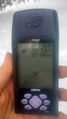
The road wasn't plowed, but there were some vehicle tracks and more people prints. The people tracks went off in a different direction again so I didn't worry about that. Coming to another narrow 'plank' bridge, I thought I better turn on the GPS and see how close I was getting. Just as I finished entering the coordinates, I looked up and saw two turkeys on the hillside not too far away. They have very good hearing and sight so I was surprised at how close I was able to get. I think they were surprised too, because they started to hustle in the other direction. They were having difficulty though as the snow was pretty deep for them and they don't like to fly. They finally worked their way around a big rock and out of sight.
Checking my GPS, it turned out I was as close as I was going to get on the trail and needed to start heading toward the hash. Sorry turkeys, I'm going to bother you some more. Working my way up the small ridge, suddenly, there was a lot of noise as the whole flock scattered and took off. Most flew off to the left in the direction that I originally was walking down the trail, some went up toward the hash and others scattered to the right.
As I followed a creek up the slope toward the hash, I was getting concerned because I still had about a quarter of a mile to go, but the hillside was about to get EXTREMELY steep(Why oh why don't I ever check the Topography when I'm hashing in Allegany???). I may have been distracted by the turkeys, but I pushed on more or less directly toward the hash. As I was working my way up the estimated 30% slope in a very wide, switchback-like route, the slope got even steeper and I was unable to keep from sliding down and couldn't gain much more altitude. Looking at the GPS, I was only about 70 meters away! Ugh, I totally should have taken a wider path to the right that I saw earlier and a likely more gentle rise to the top where it would have been WAY easier. Not wanting to give up the height I already fought for, I worked my way over that way, slipping and falling in the snow on occasion. I took off my jacket too as I was really working and sweating profusely. My fleece sweatshirt protected my arms from the snow as I fell a few more times before finally finding an easier slope to the top. *Whew* I wasn't sure I was going to make it. Even Myka was having trouble on that section and every time I stopped for a breather, I could hear her whining a little. Sorry, Myka, but we are so close! We can hold it together a little bit longer!
Checking the GPS, we were back up to around 200 meters away. This time, we were approaching the hash from above and on a much gentler slope. Closing in, we had to go down the steep section again but not very far. I wasn't able to get as close as a reading as I like, but being well within the circle of uncertainty, I called it good. We carefully slipped and slid our way back down the steep section and worked our way back to the trail. Myka was much happier once we were back on flat ground and broken snow.
On the way out to the hash, I was considering taking a Picnic Hash, joking that while I didn't have the required blanket to make it a picnic hash, there was a 'blanket of snow'. I think it was almost a tie for MNB and MNIMB and being so tired and sweaty, I didn't want to stop at the hash to eat. Back on the trail, as we were walking, I shared my peanut butter and jelly sandwich and some mixed nuts with the dogs. It was an easy walk back on the trail, and the hunter had wandered off when I got to that section. About halfway back, my legs started to complain and I was definitely feeling fatigued, but having something to eat definitely helped. Also, I think my legs are sort of used to pushing through the pain from cycling, so I was able to get back to the car without too much difficulty. But, boy, was I happy to sit down. After dropping off the snow shoes, I made pizza for dinner when I got home and had an early night...I slept REALLY well.
Photos
A bad pic of one of the first turkeys as it's running away.
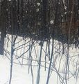
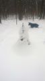
Finally getting to the top and close to the hash, a pretty good idea of the steep slope as it drops off.
Made it!
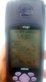
Accuracy.
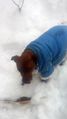
Myka, not too happy, at the hash.
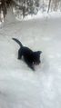
Simon at the hash; nothing seems to phase him. He's happy as ever.

Hair drenched in sweat, and out of breath, I'm exhausted, but happy to make it.
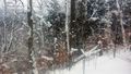
On the way back to the path, from a distance, I really thought this was a half melted snowman. Getting close, I realized I was probably just really tired.


Ribbons
This user earned the Land geohash achievement
|