2018-02-10 47 -122

| Sat 10 Feb 2018 in Seattle: 47.4780175, -122.2321579 geohashing.info google osm bing/os kml crox |
Location
Near the banks of the former Black River in Renton.
Participants
Plans
Mid-day expedition and exploration through the Black River Riparian Forest.
Expedition
Once upon a time, the Black River flowed out of the south end of Lake Washington and joined up with the White River to form the Duwamish River. It was a beautiful, meandering river, though it occasionally flooded and flowed back into the lake. The people of Seattle wanted to build a Ship Canal and connect their big lake to the sound, and because of that, the Black River disappeared.
Today's geohashpoint is on a hillside, the bank of that long forgotten river, and quite near a park set up in its name. This is probably also worth of a Tale of Two Hashes challenge.
After training on the Sammammish plateau, I headed down highway 900 to Renton and the parking area south of the geohashpoint. The end of the road was liberally peppered with no parking, stopping or standing signs, and I returned to the nearby business (now for lease) for parking.
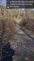
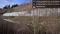
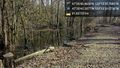
The trail into the Riparian area was muddy, with standing water visible to either side. The website shows a causeway with raised sidewalks, but this trail was not that area - it is likely to the south of here. The trail did lead directly to the gap in the railroad fence, visible in some aerial photos.
My original plan was to cut across the railroad tracks and (if no fence exists to the north) head up the hillside then laterally east to the geohashpoint, avoiding the large pond. This access was taken up by an encampment, and I opted not to trespass. The hillside was steeper than I imagined, so I headed further west to see if there was another way up the bluff.
There was, and on the way I passed a grate with the obvious sounds of rushing water - the river? Above that, a graffiti-laden wall and a retention (or dumping) pond. Above that was a cement business, clearly visible from the aerial photos. I opted not to scramble up this hillside, which looked to put me too far above the hashpoint, and returned to the railroad tracks.
Going east, I found the pond was very large, perhaps from recent rains. As I approached the eastern edge of that pond, I found another encampment, this one occupied by a dude who jumped on a bike and headed away from me.
At this point, I decided I was done pressing my luck here, and returned down the muddy path to the car.
I did take one more try from above, just east of the cement processors was an apartment complex. While this was almost as near, there were no paths down and a few dogs giving me the eye, so I again opted not to head to the hashpoint.
From both above and below I was thwarted by a lack of public access, although technically the land below belongs either to the railroad company or nobody. Still, obvious occupation was sufficient to stop my progress. Nice expedition, no point reached.
Tracklog
Photos
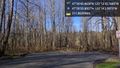
Trailhead @47.4766,-122.2341
Gap in fence @47.4785,-122.2351
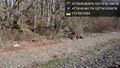
Encampment @47.4787,-122.2348
Grate @47.4793,-122.2368
Graffiti wall @47.4794,-122.2368
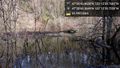
Big pond @47.4779,-122.2333
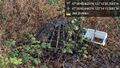
More tents @47.4779,-122.2332

above @47.4772,-122.2309


