2018-02-25 48 8
| Sun 25 Feb 2018 in 48,8: 48.8391693, 8.4881392 geohashing.info google osm bing/os kml crox |
Location
A forest near Langenalb in the northern black forest.
Participants
Plans
Go there by bull.
Expedition
I started at half past eleven in the morning. The sun was shining, the sky was blue but the air was cold and the wind was blowing. Well, it came from north-east, and so I chose the hashpoint in the south that was almost as far as the one in the north, but much higher. The first 50 kilometers were in the plain (rhine valley), and so I reached Karlsruhe-Durlach after around 1 3/4 hours. The wind came mostly from the rear and I came forward pretty fast, but when I had to face the wind for short tracks it was hard and cold. Behind Durlach I had to enter the black forest, and that means several steep slopes. The bull was helping a lot, but I was already tired, and so it took a while until I came near the hash. In the higher parts of the journey, especially when I came close to Langenalb, some snow was on the fields.
I stopped the bull 40 meters from the hash. The hash itself was just some 5 meters from the path I was following in the snow covered woods. I took some pictures and continued my way. From the hash the track went almost only downwards and 15 minutes later I reached the station in Marxzell. Well, station is a big word. It was just a closed building and two iron tracks.I knew that my train would come in half an hour, and so I decided to ride on along the street next to the track. I just rode some 2 or 3 kilometers, when I found a sign saying Schoko-station 200 m. And indeed at a nearby parking lot stood a car selling Schokoküsse (a kind of german cookies). Well, I had no means to transport them (and he could only sell whole packages containing 16 of them), but he also sold Magenbrot, another smaller sort of cookies. When I reached the next station, I still had plenty of time, and so I decided to go on - And so did I for the next 4 stations until I reached Ettlingen.
At the station I bought a ticket and waited ten more minutes for the train to Karlsruhe. In Karlsruhe I had 20 minutes for the train to Speyer, and waited with a burger inside MacDonalds because it was warmer in there. In the train the conductor told me, that I would have had to stamp my ticket, and I should leaf the train at the next station to stamp it, otherwise he would charge me 60 €. So did I. I would even have made it into the train again, if - the stamping machine would have worked ... But so, I found me once again at a cold and windy platform. But at the station was a coffee shop, where I could get a hot coffee and wait in the warmth for the next train, half an hour later. Well, this time I was sure, I had a ticket named Speyer, and it was stamped. So I was pretty cool, when the next conductor came, just before Speyer, but she told me, that my ticket is only valid to Lingenfeld, and she was confused, why "Speyer" was printed on the ticket. Nevertheless, she didn't charge me, and so the long journey found a conciliable end. I reached home at half past five.
Tracklog
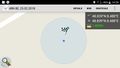
Well, the app crached while storing my track, and so I can only show you the planned way to the hash: 74 KM. All in all I rode 88 KM by bull and an unknown amount of kilometers by train.
Photos
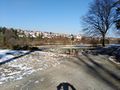
view to Langenalb from where I parked the bull
view to the hash, 35 m between the two pathes
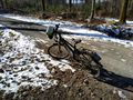
bull (proof of transport)
proof
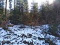
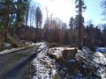
view into the forest (south)
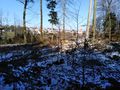
back to Langenalb and the bull(you can find it behind the tree in the middle)
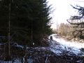
the nearby path

happy hasher


Achievements
probably just land
DODO earned the Land geohash achievement
|