2018-04-17 40 -77
| Tue 17 Apr 2018 in 40,-77: 40.0899530, -77.7342830 geohashing.info google osm bing/os kml crox |
Location
Just in the woods off Lower Horse Valley Road near State Game Lands #76
Participants
Expedition
Note: I was on a trip to visit my brother in NC and am currently on my way home today for this expedition. I picked up a Hash the day before on my drive to Maryland where I spend the night at a friend's house to break up the drive.
I left my friend's place around 09:00 and stopped at a bagel shop for some breakfast timing it well for the posting of the new Hash-points for the day. Looking over the Graticules near my route I first saw one that looked accessible outside Baltimore, but upon further research, I found that was actually on a Military base and I wouldn't be able to get there. Next, I saw this hash in Pennsylvania that wasn't too much of a detour and looked to be on public land. Since I didn't have a pen to update my written directions, I just used my phone navigation to find my way to this hash.
Getting to the Hash-road, I found a spot to pull over and started walking up the path next to the clearing you can see in the satellite images(I thought I remembered the hash being up that way). When the GPS found its location, it said I needed to head back toward the road. Closing in on the hash, I ended up in the middle of the road and got a close enough reading to count and a couple pictures. Walking back to the car, I thought about it and was REALLY sure the hash should have at least been in the woods. Rechecking the coordinates, I realized I was off by a couple thousandths when I entered them in, and after correcting, went back in search of the real spot...whew, just missed another Blinded by Science consolation!
I was only off by about 10-20 meters, but still...Locating the real point, I couldn't get a lower reading than what I had on the road. Retaking the pictures for proof, I got back in the car and started heading back the way I came but quickly realized I wasn't sure which way to go. Being in the middle of no-where, I had no phone signal for the GPS and ended up retracing my route back to the little town that wasn't too far from the hash. I was pretty sure I needed to go the other way, but without a signal and not knowing how far I would have to go until I got one, I played it safe and went a little out of my way to get a signal. Confirming I had to go the other way, I was back on track to Buffalo.
Since the hash also landed in Allegany State Park in the Buffalo Graticule, and because I had to drive right by there on the way home, I turned today into a Multi-Hash as well. You can find Part 2 of today's expedition here.
Bonus: There is more than one Expedition for this day, but I am the only one Geohashing on a Multi-Hash so these two should be a Last Man Standing.
Photos
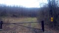
An old road by the clearing seen in the satellite pics. I was going to park in front of the gate but the signs say "DON'T BLOCK THE GATE!"

I made it! (or did I...)

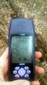
Accuracy to which turned out to be slightly off the actual hash-point.
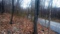
Fixing the coords, I get close again; this time in the woods on the actual hash-point.
A view from the hash looking at the loaner Hash-mobile.

Happy to avoid the consolation prize.
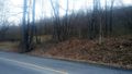
Back at the car, a look at the hash.


Ribbons
This user earned the Land geohash achievement
|
Pedalpusher earned the Last Man standing achievement
|
Expeditions and Plans
| 2018-04-17 | ||
|---|---|---|
| State College, Pennsylvania | Pedalpusher | Just in the woods off Lower Horse Valley Road near State Game Lands #76 |
| Buffalo, New York | Pedalpusher | Allegany State Park, in the woods behind the cabins of the Beehunter Cabin ... |