2018-06-12 31 35
| Tue 12 Jun 2018 in 31,35: 31.7484099, 35.1008393 geohashing.info google osm bing/os kml crox |
Location
Aminadav: Canada Jerusalem Hills Forest.
Participants
Plans
Wake up at around 5:00 AM before work in order to get there on the way to work and then run through the forest using my Google navigate application. I live near Ashkelon and work in Jerusalem so it should be on the way. I visited the day before just to scout out parking spots.
Expedition
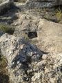
Getting there by car was pretty smooth, though kind of long. I found that there were a lot more trails than were marked on OpenStreet Map so I was able to get to other places quite smoothly. The marked trails are very flat and seem to circle around the mountain side barely leading upwards. On the way up I bush-whacked quite a bit more than I should have, but most of my passes were on unmapped trails. At the end I reached the hillside and bush-whacked another forty meters up-hill. I continued up to the ancient wine press trail where I got some nice pictures.
Tracklog
Photos
What are ma'abarot?
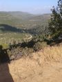
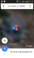
The point is somewhere down there
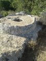
ancient wine press
ancient wine press
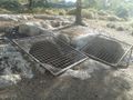
ancient wine press, modern grate
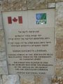
When I got there I thought it was a parking lot. Then I read the English and realized that the name for "parking lot" and "picnic area" are the same in Hebrew. I guess I was correct not to drive, thought it would have saved me time.
proof


