2018-07-01 49 8
| Sun 1 Jul 2018 in 49,8: 49.2461185, 8.2520957 geohashing.info google osm bing/os kml crox |
Location
A field near Oberlustadt
Participants
Plans
Go there by bike. ETA 14:00
Expedition
Well, almost as planned. I started 20 minutes later than expected but rode faster, so I reached the hash around 14:15. My first impression of the hash was a wheat field, but the hash was behind this and even behind the next field with beetroot., just at its edge to the next field, where not much grew. I just had to walk for 30 m between the two fields to reach the circle of uncertainty. And with a step into the beetroot, I reached a 1, what was very much good enough. I returned to my bike and continued my way (still working for a torn): I had to cross a very muddy part because they were watering their fields (and also the paths between them), but after 200 m I reached the street again and came home at 15:05. Iron worked, as you can see on the tracklog :-)
Tracklog
Photos
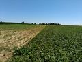
a30 m in this direction

proof

happy hasher
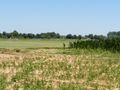
view to the east
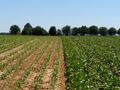
to the south
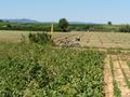
and to the north, bike is pretty close)


Achievements
DODO earned the Land geohash achievement
|
DODO earned the Bicycle geohash achievement
|
DODO earned the Tron achievement
|