2018-07-06 43 -71
| Fri 6 Jul 2018 in 43,-71: 43.5166381, -71.7751081 geohashing.info google osm bing/os kml crox |
Location
Wooded area, Hill, NH
Participants
Expedition
On vacation in New Hampshire, but it was a beautiful swimming day and I couldn't convince anyone else to leave the lake.
It looked like a long shot. The hashpoint was in woods, apparently privately owned, just outside a powerline right-of-way with a public road along it. I thought the probability of success was fairly low, either because there would be No Trespassing signs at the edge of the right-of-way, or the right-of-way itself would be an impenetrable thicket and I wouldn't be able to get from the road to the woods.
Several things about my expectations were wrong. The driveable road stopped about half a mile from the hashpoint, well short of the power lines, turning into a wide rocky trail suitable for horses and maybe Jeeps but definitely not the day's hashmobile. Signs at the end of the main road indicated that the area had come under some sort of conservation agreement, and a set of mountain bike trails was being developed. The posted map indicated the conserved area did not include the hashpoint, so I still thought the odds of success were pretty low.
I walked along the trail, looking anxiously to the left for No Tresspassing signs but not seeing any, until I thought it was about time to turn into the woods. I then took a slow and circuitous route through open New England woods. After about 20 minutes I arrived at the hashpoint. It was, no kidding, in the middle of a woods road about which my advance map-reading had given me absolutely no clue.
The trip back to the car was much more direct, since the mysterious road connected to a newly-developed one, which connected to the trail I had already traveled.
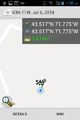
Proof.

Grin.
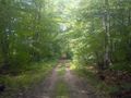
View S from hashpoint.

Sunset later that evening, back at vacation cabin.


