2018-07-07 29 -81
| Have you seen our geohashing marker? We'd love to hear from you! Click here to say "hi" and tell us what you've seen!
Curious about what geohashing is? Read more! |
| Sat 7 Jul 2018 in St. Augustine, Florida: 29.9389184, -81.4879861 geohashing.info google osm bing/os kml crox |
Expedition
The Plan
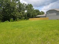
In a subdivision near Mill Creek. We're already going to be out and about in the area as it stands, so might as well swing over and nab this one. Google doesn't have street view there, but the closest it shows is construction.
The Geohashers
The Adventure
It's nice to be able to write these again, even if the adventure really boils down to "I drove two miles out of my way to stand here." I hadn't been able to do any sort of unplanned travel for almost two years due to mental health issues, so being able to look at the hash, even this close, and start formulating even a basic plan allowed for a feeling of a return to normalcy. This may mark the first time anyone has said geohashing made them feel normal. To my surprise, Erica, who had sprained her ankle a few days before, was willing to come with. In turn, she was surprised I was still looking up geohashes. I opted to do the geohash before the errands due to a major storm blowing through; when given the choice between a sunny geohash and trying to take pictures and protecting electronics in torrential rain, I'll usually go for the former.
Given the speed I've seen new subdivisions spring up in the past few years around here, this was going to be quick one way or another. Either it was still accurate and we could run out and get it, or it was now somebody's house but at least it only took five minutes. As it turned out, it was a bit of both; the subdivision had sprung up, but the geohash was in a still empty plot near a dead end. Cue the Geohash Dance! Minus Erica, who stayed in the car thanks to the sprained ankle.
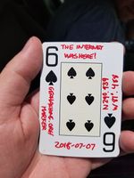
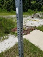
With that, we left the Six of Spades rolled into the dead end sign. Closing in on finishing off this deck!
Gallery
- Photo Gallery


