2018-07-15 57 -6
| Sun 15 Jul 2018 in 57,-6: 57.8757748, -6.8170045 geohashing.info google osm bing/os kml crox |
Location
A couple of miles south of Tarbert on the Isle of Harris
Participants
- milwryaeth
- AmritOfTheMaps
- Millicent
- Vesper
Plans
We are staying at a holiday cottage on the Isle of Harris for a week and a bit, and thought we'd try geohashing, especially since it seems no-one's done it in the Outer Hebrides before! Today's location was gloriously near our cottage, about a mile away, so it didn't take much more planning than deciding to go, and then going.
Expedition
Left our holiday cottage about 4pm, on a grey and wet day, but it wasn't actually raining at the time. The walk was about half a mile up the "Golden Road" and then a little more on the A859 before we'd have to leave the road. We walked slowly, stopping to admire such things as sheep, rocks, little lochs, wildflowers and amazing views (which constitute a lot of what there is to see on Harris). We left the road to walk the last few hundred yards to the coordinates, which were a fairly nondescript boggy patch of ground near a small stream and several large rocks, looking much like most of the West Coast of Harris does.
Walked back by a different route, making our way down the hillside to the sea shore to meet the Tarbert-Miabhag footpath and going back home along that.
Tracklog
Photos
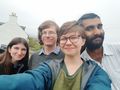
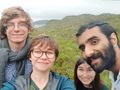
Setting off selfie!
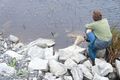
Milwryaeth admiring flowers in a little lochan
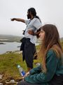
AmritOfTheMaps points something out to Vesper
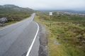
Walking along the A859
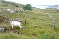
A local resident of the woolly variety
Faces of joy having arrived at our destination!
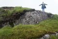
Milwryaeth's pose of achievement shortly after reaching the hash

AmritOfTheMaps's face at the hash point
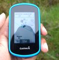
Proof!
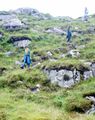
Millicent, Vesper and Milwryaeth adventuring down the hill to the footpath on the way back


Achievements
Milwryaeth and AmritOfTheMaps earned the Land geohash achievement
|
Milwryaeth and AmritOfTheMaps earned the Graticule Unlocked Achievement
|