2018-07-24 47 -122
| Tue 24 Jul 2018 in Seattle: 47.7165716, -122.3035600 geohashing.info google osm bing/os kml crox |
Location
The back yard of a house in Victory Heights, north Seattle.
Participants
Plans
Appears to be the back yard of 12026 23rd Ave NE; neighboring back yards seem to have been turned into a p-patch or community garden. May have to investigate from all sides.
Expedition
The Seattle road known as Lake City Way was once known as the Victory Highway, referring to World War I. This development of homes on a hill side above that was known as the Victory Heights development, and I read a bit about it on the Times.
I started out with a visit to the northern branch of Thornton Creek, which meets up with its southern branch not far from here and eventually flows into Lake Washington.
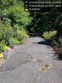
Next came the road north of the point, which did not lead to a community garden but to a wall of undergrowth. I doubt the neighbors would appreciate my machete wielding skills, so I returned to the car and drove to the top of the hill.
The house was not for sale, so no excuse to wander into the undergrowth of the back yard - and a desire to finish my commute to work - led me to drive on to the south of the point.
Victory Heights is aptly named, and the hill south of the point was quite steep. I spotted one unmarked driveway leading towards the point, so I parked and walked in - but found it only led to a garage. The actual point was still two properties over.
Finally I returned to the street west of the point and continued north to work. No success, but an interesting visit and a bit of Seattle history learned.
Tracklog
Photos
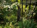
Thornton creek @47.7177,-122.3019
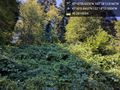
North of the point @47.7169,-122.3034
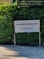
Buddhist @47.7191,-122.3046
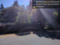
West of point @47.7165,-122.3045
South @47.7161,-122.3033


