2018-08-02 42 -85
| Thu 2 Aug 2018 in 42,-85: 42.9060735, -85.5119402 geohashing.info google osm bing/os kml crox |
Location
Former golf course, now park within housing development, Forest Hills, MI
Participants
Expedition
The hashpoint showed up just at the edge of a green area on the street map, making me optimistic that it could be reached without crossing private property.
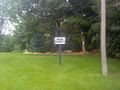
It took two tries. I first parked on Charlevoix Drive SE, where it crosses the green area. At that point a very unwelcoming Private Property sign blocked my access.
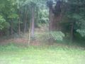
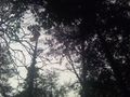
I decided to drive around and try from the other side of the hashpoint. This required about 1 km of driving to actually move about 100 m. From there I was able to enter the woods with no violation of No Trespassing signs and work my way by a U-shaped path to the hashpoint. The only creature I encountered was a hawk who was clearly not too happy about my presence; he screeched several times from his perch 25 m or so above me.
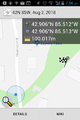
First approach,
encountering barrier,

resulting in frown.
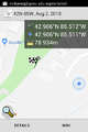
Second approach,
no obvious legal barrier,
annoying this hawk,
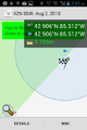
resulting in Proof.


