2018-08-18 49 8
| Sat 18 Aug 2018 in 49,8: 49.2559133, 8.5266482 geohashing.info google osm bing/os kml crox |
Location
In a forest next to Waghäusel.
There is an Erimitage and a pilgrims church in Waghäusel but I visited neither of them (they wern't open at this time anyway).
Participants
Plans
Have to drive the lady to Germersheim very early in the morning (5:45). Try to visit the hash on my way back home.
Expedition
It is a 20 minutes drive from Germersheim to Waghäusel, where I left the car. I had to climb over a guardrail to get on the main road (L555). I crossed the rtoad and foud a way into the fields. I came along a compost plant and a purification plant. After that, the way turned right into the forest. After a while I found another way to the rigth and just reached the hash on this path. According to OSM this path should end at the hashpoint, but it obviously continued, leading exactly into my direction. So I followed it. I could almost see the street again, but I could also see, that the path ends before it reaches the street and so I turned left again and reached the other side of the field where I had crossed that street. That path ended there but I could easily reach the street along the edge of the field. From here it was easy to reach the car again and drive home.
All in all a 3 KM walk and a 32 KM drive (instead of 16 KM, I had to drive home the direct way.
Tracklog
Photos

proof
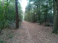
path seen from the hash: to the north
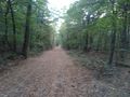
and to the south
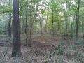
view into the forest

Happy Hasher
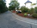
back at little car


Achievements
DODO earned the OpenStreetMap achievement
|
DODO earned the Land geohash achievement
|