2018-12-15 47 11
| Sat 15 Dec 2018 in Innsbruck: 47.9223184, 11.7570495 geohashing.info google osm bing/os kml crox |
Location
Today's location is in at the edge of the Hofoldinger Forst forest south of Munich, near the Kreuzstraße (literally: cross street) village.
Country: Germany; state: Bayern (Bavaria, EU:DE:BY); administrative region: Oberbayern; district: Miesbach
Expedition
Danatar
I was in Munich for the weekend to meet friends. When the coordinates were announced I noticed that they were a bit outside the city but very near to an S-Bahn (suburban railway) station. I didn't have any appointments for the afternoon so I planned to take the train shortly before 3 p.m. which would arrive at that station at 15:39, leaving me enough time to reach the spot by 4 p.m.; I would then take the return train at 16:24 and arrive back in Munich an hour later with enough time before my evening appointment.
Saturday I had brunch with a friend and then we visited an exhibition about optical illusions. That expedition showed trompe-l'oeil paintings, sculptures looking like something else (the marble apple was awesome!) and had Virtual Reality headsets. The expedition as much bigger than we expected and there were long lines for the VR stuff, so we stayed longer than planned. By the time we left and parted ways at the Marienplatz it was already 15:30. I wouldn't make it to the hashpoint in time for hash o'clock but I wanted to visit the spot nonetheless, as it would be a new graticule for me, I had already bought a day ticket and I had nothing else to do until the evening. So I took the S7 train one hour later than planned. The ride was fine until Aying station but there the train stopped. After a few minutes there was an announcement about technical difficulties and finally a replacement train came. Due to this delay I arrived at Kreuzstraße station at 5 p.m. I knew that time would be a bit tight so I quickly set out towards the hashpoint, hurrying along the dark street. While in Munich there was no snow and I had only seen a bit of snow north of Munich on Friday, here there was a complete layer of snow of 5-10 cm next to the street. Soon I left the village and reached the forest where the hashpoint was situated. I entered between the trees and hurried through the underbrush, lighting the way with my phone's flashlight. My hurrying had not only been because of the return train (there would be more, although I would have to wait quite a bit and would be late for my evening appointment) but also because my phone's battery was rapidly draining. It's already 5 years old and I knew that below 30% battery charge there would only be a few minutes of power left. Navigating was a bit difficult and I reached the hashpoint with 13% (thanks, flashlight for draining it even faster!), instantly snapping a screenshot of the map app (geohashdroid doesn't show the track you took) showing me at the spot. Next I planned to take a selfie, a picture of the hashpoint and then send proof of the coordinates to this page here with geohashdroid. While taking the selfie there was a vibration (probably an error message) but the flash had activated; when I tried to take a picture of the ground one second later I noticed that the phone was already dead. D*mn, I had needed just one minute more...
Now I was in the dark forest without a light and without a working phone, with about 10 minutes until the next train but not knowing exactly how long because I don't have another clock except the phone. Without taking any looks around I started out of the forest, luckily the moon was bright enough that I knew which direction to take and just showing enough of the snowy ground to see by. Soon I could even see my old track. I came back to the street and started towards the train station, partly jogging and partly speedwalking. I reached the train station with two minutes to spare and boarded the train that was already waiting. On the return ride there were more delays as the technical difficuties on the train track hadn't been solved completely, but those amounted to only a few minutes each. I finally came back to Munich and made it in time (with my phone slightly charged again after a short time at the hotel) to my evening appointment.
This is the third expedition in a row where I reach a Saturday spot but not at 4 p.m., which is a bit annoying. But each of those three were new graticules for me at least. I planned to visit Munich's Sunday hashpoint, too, because it also should have been easy to reach but I only had time in the afternoon and I didn't want to walk 5 km in total darkness.

Kreuzstraße train station, it's already dark
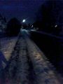
street towards the hashpoint (picture brightened)
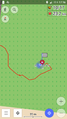
phone gps track screenshot at spot
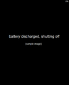
no stupid grin documented :-(
no hashpoint documented :-(


tracklog
phone GPS tracklog As the phone's battery died just seconds after reaching the spot, the tracklog ends there. I'm glad that at least the trackpoints are saved automatically by the app.