2018-12-30 -36 147
| Sun 30 Dec 2018 in -36,147: -36.9933206, 147.3097163 geohashing.info google osm bing/os kml crox |
Deep in the bush north of Dinner Plain.
Participants
Plans/Expedition
While staying in a hut up at Dinner Plain, I was looking for a solo bike ride adventure. Somewhat late in the day I thought of geohashing. I had about 6 hours until I needed to be back for dinner. Could be tight.
The point was ridiculously tantalising. Given that most of the terrain in that area is completely inaccessible, with steep hills, few tracks, dense bush...here was a point close to both a walking track and a hut, and on relatively flat ground.
But how to get there? I thought of three routes, which were all complex, with combinations of driving, cycling and walking, and would all be really pushing it to make it there and back in 6 hours.
In the end I tried them all.
Attempt 1
First, I drove down the Great Alpine Rd towards Omeo, to pick up a dirt road. I hoped to get as far down it as possible in the car, before switching to bike, then getting onto the walking track. I didn't expect to be able to ride up the walking track at all.
As it turned out, the dirt road on my map simply didn't exist, at all. I went back and forth along the road where it was meant to be. There was simply an unbroken fenceline, with vegetation. There was no sign that there had ever been any track in that location.
Attempt 2
Next, I went further down the road to a different dirt road. This would be a much longer route, and would approach the point from the north via a big loop out to the northeast. I wasn't confident I would have the stamina and speed to make it through such rough terrain in time, nor was I sure how far the car would get down the road.
As this one turned out, the road was marked "private", in several places, and was very rough. I went a short distance down before feeling really uncomfortable and turning back.
Attempt 3
My last option was a real long shot. I took the car back towards Mt Hotham, to Brandy Creek Track. My map showed a track down to the bottom of the gully, then some minor walking track along the creek. In theory, it might be possible to ride down the track, and then along the creek, and eventually connect with the walking track up to the point. I was pretty doubtful that the track would be rideable, and if it wasn't, it was much too far to walk the whole way.
I blasted down the steep four-wheel drive track, knowing that I could never ride back up it. At the bottom, the track remained rideable for a bit, until it crossed the creek. I carried my bike over, and got onto some single track. But the track began to get buried in long grass, with lots of little fallen logs. I knew it pretty quickly it was hopeless, but kept riding a bit for shits and giggles. Eventually the giggles ran out, so I turned around. Pushing all the way up the steep track wasn't really as bad as I imagined. There's something kind of calming about doing a task that has absolutely no alternatives. I met a few people walking down who gave me a few odd looks, which is how you know you're doing it right.
Tracklog
Photos
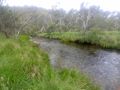
Brandy Creek
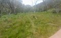
The singletrack peters out completely in the long grass.
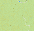
Topo map showing the point.


