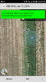
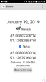
2019-01-19 45 -91
| Sat 19 Jan 2019 in 45,-91: 45.0080221, -91.1268286 geohashing.info google osm bing/os kml crox |
Location
A farm field / country road near Cadott, Wisconsin.
Participants
WausauBill (talk) and his GPL (Either "Geohashing Partner for Life" or "Geohash Positioning Liasion" take your pick).
Plans
Looking at the hashes for the weekend I noticed that they lined up along State Highway 29, a main east/west route through our area. Unfortunately, the hash closest to my house looked pretty inaccessible on the map, but the next two were close enough to roads that they both looked like possible Speed Racer achievements.
There was also a super easy hash in Minneapolis as well (on a baseball diamond at a school) but bitter cold weather moved in and we decided that a trip to Minneapolis was not something we wanted to do when the temperatures were below zero.
Expedition
The first hour of the expedition was uneventful, just tooling down the highway. The day was very cold, but the sun was out and the roads were perfectly clear.
When we got within 10 miles of the hash, things got interesting.
First, Google maps decided to send us round and round to get to the spot. We exited off the freeway following the Google Magic Voice instructions. Right turn here, drive two miles. Then a left. Then another right, etc. Finally she said we were there. Later on our way out we realized that had we taken the next exit off the freeway, we could have driven straight up a state highway for a few miles, turned right and been at the same place. Thanks for the help Google!
But we were there. We were on a slight hill next to a farm field. There was a ditch by the side of the road and then a steep incline up to the field itself. The incline was maybe 5 or 6 feet high. The phone indicated that the exact spot should be right at the edge of the field, just over the incline.
My lovely GPL took the lead and scrambled up the incline, however about the moment she was about to hop up into the field it happened -- velociraptor attack!!
Too quick to get the camera the velociraptor repelled my GPL's attempt to enter the field, knocking her back and I watched helplessly as she rolled back down the incline. But as quickly as it struck, it vanished. We righted ourselves and looked for another way to enter the field. Looking at the phone, it told us that (unlike a minute ago) we were on the hash. We screenshotted the moment quickly before the phone changed it's mind again.
Success!!
After completing our documentation, as mentioned before, instead of backtracking through the convoluted directions, we were able to just go about half a mile down the road and turn onto a state highway that took us back to the freeway. There we found the Cadott Family Restaurant. There we had our lunch and enjoyed our Hash hash, pictured below.
When we finished with lunch, we headed down the highway to the next hash!
Photos
Proof Number 1
Proof Number 2
- Error creating thumbnail: Unable to save thumbnail to destination
GPL and I at the hash site.
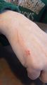
Velociraptor Wounds!
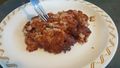
Geohash hash!


Achievements
WausauBill (talk) and my GPL Kathy earned the Graticule Unlocked Achievement
|
Error creating thumbnail: Unable to save thumbnail to destination |
The only expedition listed on the page currently is an unsuccessful one, so I claim this graticule!
Kathy, GPL of WausauBill (talk) earned the Velociraptor Geohash Achievement
|