2019-01-28 50 8
| Mon 28 Jan 2019 in 50,8: 50.1515072, 8.2595235 geohashing.info google osm bing/os kml crox |
Location
In the woods behind the "Jakobi Park" in Niedernhausen.
Participants
Plans
Day off, yay! So why not walk all the way to the hash, biking is not my thing and it's a mere ~ 7.5 km ...
Expedition
Good plan. What I did not anticipate was the snowfall the night before so plans changes slightly with me having to remove the snow from the curb of not just one but two properties.
After I'd done that, I started on the expedition. The walk took me from Niedernhausen Oberjosbach through Niedernhausen central past the "Jakobi Park" into the woods on the other side. It was quite beautiful walking in the snow with everything around me being white as well.
Things started going south when I got closer to the hash as I decided to use a not so obvious path (which was marked in OpenStreetMap mind you). A mere five meters in I discovered that there where huge water puddles below the snow and promptly stepped in one of them with both feet. Fortunately barely any water got through to my feet and I managed to keep them warm enough by simply pressing on.
The last 200 meters I had to go through dense forest without any paths but with the occasional wild boar scaring me to death. The final 20 meters I had to scale up a steep incline (hashes are always on hills, right?). Coordinates reached!
I took a slightly different way back which allowed me to use much better paths to get back to Jakobi Park. By then I started noticing that I'm not used to walking 10+ km anymore so I stopped for a lunch break before making my way back home.
All in all, it was a ~ 15 km trip through the snowy hills in Niedernhausen, my knee made sure to let me know the following day that it did not approve but it was totally worth it :)
Tracklog
See here.
Photos

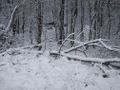
This way up to the hash
- Error creating thumbnail: Unable to save thumbnail to destination
The hash, yay!
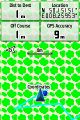
Coordinates reached
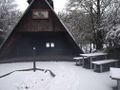
Jakobi Park Hut
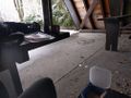
Having lunch there


