2019-04-14 62 30
| Sun 14 Apr 2019 in 62,30: 62.6625758, 30.1490940 geohashing.info google osm bing/os kml crox |
Location
In a forest near the village of Selkie, close to small forest roads.
Participants
Plans
(Planned on the previous day, 2019-04-13.)
I plan to reach this geohash by cycling here from Joensuu. In summer or autumn, I could easily cycle to 60 metres away and walk to the hashpoint, but now I cannot count on the small forest roads being clear of snow. Since these forest roads are probably not maintained in winter, there may still be too much snow (easily more than ten centimetres) for cycling. In the worst case scenario, I will have to walk about 1.5 kilometres from Keskijärventie, but it is still a manageable distance.

Expedition
I left from home in Joensuu at about half past eleven. The sky was overcast, and the temperature was 8 °C at my home when I left. All public roads were clear of snow and ice and thus easy to cycle on. As I travelled to the east and gained some altitude (from 80 m up to 160 m), the amount of snow on the side of the road and in the forests seemed to increase. I decided on the route approaching the hashpoint from southwest and hoped that I could cycle at least to the terminating loop 540 metres away. But alas, I had to abandon the bicycle a lot earlier, with 1.4 kilometres to go. There was way more snow than I anticipated, about half a metre, and it was impossible to walk on. I realised that I would have a very demanding trek to the geohash, and turning back was not really an option anymore.
I noticed that there seemed to be less snow in the forest than on the road, and so I decided to go there and walk to the compass direction. Even there, the snow was deep enough that I could not really walk most of the time; I had to move much of the distance on all fours or sitting in the snow and pushing myself forwards with my legs and arms. I made steady progress, but extremely slowly. It ultimately took me almost two hours to travel the 1.4 km and to reach the hashpoint. Sometimes I got more stable ground under my feet, sometimes (especially on the swamp in the last 100–200 m) I sank to metre-deep snow and could barely climb up. But I consider Mother Nature my bitch and would let nothing stop me.
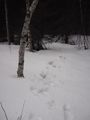
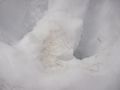
At the bottom of the final hill, about 50 metres from the hashpoint, I found criss-crossing moose tracks and many piles of manure. Apparently a moose lives in this area. I was not able to see or hear it, but then it would have had enough time to hear me and flee, if it even had been here today. Eventually, metres to destination reached single digits, and I reached the hashpoint. The GPS did not seem to know where the point should be, but finally I found a spot where the distance stayed at less than three metres. There it was, my first ever geohash! I did a little geoflashing to mark the point in snow and could not resist building a snowman as well. Right at the same time the sky began to clear up, and the sun began to shine.
After spending perhaps 20 minutes at the hashpoint, I started the trek back to the bicycle. The route through the swamp had been very tough, and so I wanted to see if the trail to the northwest was any easier. To my surprise, there was a snowmobile track that supported me very well. I walked along it to the west and ended up in a turnaround, after which the trail was almost clear with only a few centimetres of snow. Apparently the local people have been using this forest road throughout the winter and kept it clear. If I had known this beforehand, I could have used this road and made my trip about two hours shorter, though way less adventurous. I walked all the way to Selkientie and went to pick up my bicycle. After climbing up the hill with it (about 30 vertical metres!), I could head back to Joensuu. I was back at home at quarter past six.
According to my GPS, the total length of my trip was 55.1 km, of which I walked 5.9 km. However, I measured using the topographic map that I had walked only about 4.8 km. The real walking distance is probably between these figures because I zig-zagged a lot and gained extra distance due to GPS noise at very low speed.
Tracklog
You can really see the struggle where I crawled from the bicycle to the hashpoint.
Photos
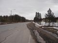
Major road to Ilomantsi.
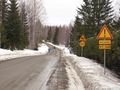
Smaller road to Selkie.
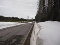
Further down the road, looking more snowy.
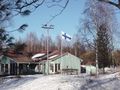
Village road of Selkie.
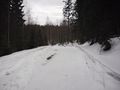
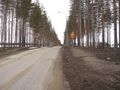
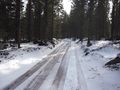
Forest road towards the hashpoint.
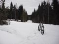
My trusty geomobile.
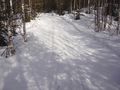
My track in the snow.
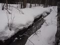
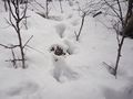
A ditch in the forest.
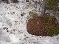
A live anthill.
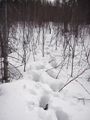
More of my track in the snow.
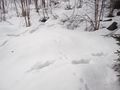
Moose and hare tracks.
Moose manure.
Moose hair.
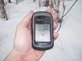
GPS proof: hashpoint reached.
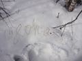
Hashpoint marked in the snow.
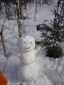
The snowman I built.
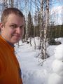
Me at the hashpoint.
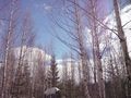
The sky is clearing up.
Snowmobile track back from the hashpoint.
Nicely walkable forest road.
The Finnish flag flying for the parliamentary election.


Achievements
Kripakko earned the Land geohash achievement
|
Kripakko earned the Bicycle geohash achievement
|
Kripakko earned the Snowman Geohash Achievement
|