2019-07-03 43 -71
| Wed 3 Jul 2019 in 43,-71: 43.7998468, -71.6487058 geohashing.info google osm bing/os kml crox |
Location
hardwood forest, Campton, NH
Participants
Expedition
The expedition succeeded but I'm an idiot.
The hashpoint wasn't far away and didn't look difficult to reach - in hardwood forest maybe 400 m from the end of a road in moderate terrain. But it was apparently on private land so the odds of encountering a Private or No Trespassing sign before I could enter the woods was pretty high. Therefore, when I picked up the bugspray before I left home, I thought "Don't spray it on yet; you may not need it. Just put it in your pocket, and spray when you get to the parking spot if it turns out you have access to the woods." I then set the bottle back on the porch railing and left it there. Doh.
I also left my compass - brought here specifically for use on geohashing expeditions - in my backpack.
In fact there was no problem with access. The road I saw on the satmap led to a clearing with a pile of gravel and evidence of woodcutting activities. I parked in the clearing and realized the bug spray wasn't in my pocket. It was clear that there would be both mosquitoes and ticks to contend with in the woods, but having come this far, I plunged ahead. The GPS indicated about 400 m to the goal.
There was an old logging road (I guess) leading generally in the direction of the hashpoint, as I had suspected from a dark path in the tree canopy that had appeared on the satmap. It took me about halfway there. At that point I left the trail and navigated through the hilly forest. There were soft layers of leaves from the deciduous trees on the forest floor, and not too much undergrowth, so the going was not too difficult. But the tree cover made the GPS respond slowly, and the little direction-of-travel arrow was intermittent and unreliable. (Old rule of thumb from numerical analysis: if the signal is noisy, the derivative is noisier!) I had I think the most frustrating hashdance I've ever experienced, with a working radius of nearly 90 m, before I managed to converge on the hashpoint. The compass I left at home would have helped a lot.
Once I finally found the spot I didn't stick around because the mosquitoes had definitely found me. The woods looked the same in every direction. I navigated back to the logging road with a combination of dead reckoning, the sun showing me west, GPS Droid showing me I was moving away from the hashpoint in the right general direction, and highway noises.
Back at the car I threw off one tick that was wandering around on my leg looking for a permanent home and returned to base.
The photo on the main page gallery was taken a few miles away, at the south end of Newfound Lake, later the same day.

Proof

Grin
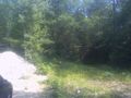
Entrance to woods along old road
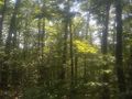
View from hashpoint


