2020-02-24 42 -78
| Mon 24 Feb 2020 in 42,-78: 42.8762543, -78.7997395 geohashing.info google osm bing/os kml crox |
Contents
[hide]Location
In the very center of the I-190 between the Ogden St Entrance and Exit ramps
Participants
Expedition
This evening I was meeting our Broomball team downtown at our Sponsor Bar before the Playoff game at 21:15. Since this hash wasn't too far out of the way, I was thinking I could hit this hash within the Circle of Uncertainty while staying in the Left Hand lane just driving by. I knew I would only get one shot at this (well, technically two since I could try again on the way home if I wanted to take the long way), so I had to do this right.
Before leaving the house, I practiced holding the GPS and the steering wheel with one hand and taking a video on my phone with the other. That worked well so I then did the same thing, glancing down quickly to line everything up and start the video and then looked back up to watch where I would be going if I was driving. I waited about 10 seconds (what I estimate it would take to drive through the hash area) and reviewed again what I had. I maintained a steady hold on the GPS and the background light stayed on for the duration. This looked like it would work.
I drove over to the hash and turned on the GPS when I got off the 219 (North) to the 90 (East) to give it plenty of time to find a signal. Getting to the 190, I picked up the GPS and positioned it in my driving hand and got my phone on the Camera (simple double hit of the power button). Getting to the hash area, I couldn't drive the speed limit because there was a pickup truck in front of me so I couldn't set the cruise control like I was planning for the Speed Racer.
Anyway, getting to the exit, I started the video of the GPS and was sure I had it running long enough to catch whatever happened. Turning off the phone and the GPS by feeling for the Power buttons, I put everything in my pocket and finished the drive to the bar.
I was the first one from the team there so I ordered a beer and reviewed what I had. Uh-oh. The closest distance the GPS recorded was 27 feet, and the Circle of Uncertainty was only 20 feet. Looks like I'm going to have to call this Not Reached unless I want to try going back this way again on the way home. We'll have to see.
The rest of the team got to the bar and we had a drink or two before heading to the Ice at Canalside for the game. It was a close game through two periods with us down 4 to 3 (and I got our first goal!), but needing to tie it up in the third, we started to take some chances. Unfortunately, the other team picked up a couple more goals and we ended up losing 8-3. Better luck next year. Since we were playing the late game, it was after 22:00 and I didn't feel like going the long way home so I figured I'd just call this Not Reached when writing it up.
BUT WAIT! Looking at my tracklog and Google maps, I'm now thinking I was actually within the Circle of Uncertainty and may be able to call this a Success! From the Garmin BaseCamp maps, it looks like the Hash is maybe but not quite a quarter of the Scale away (Close to 20 feet) if you take the whole square marker into account. The Google Maps view is even better. I took a screenshot of the Google Maps, then took a second screenshot of just the Scale of the map and rotated it 90 degrees. On Google maps, 20 feet actually covers the entire Left Driving Lane of the 190 where I was. Based on these maps, I think the GPS just didn't have an update point close enough to the hash to display. From the Google Maps, I estimate I was within 13-15 feet (3 meters) and in a car, that's close enough for me.
Based on my analysis, I think I've talked myself into a Successful Expedition, but please leave your thoughts and feedback as well. If others disagree, I'll change this to 'Not Reached'.
Photos
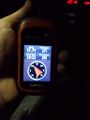
Screenpull from the GPS Video. Doesn't look like I made it.
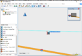
Garmin Track Map - This actually looks pretty close after all.
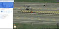
Google Maps view - That's definitely within 20 feet!


Ribbons
This user earned the Land geohash achievement
|