2020-04-23 48 11
| Thu 23 Apr 2020 in 48,11: 48.1414145, 11.1503884 geohashing.info google osm bing/os kml crox |
Location
In the woods north of Grafrath, 7 km west of Fürstenfeldbruck.
Participants
Plans
Friday afternoon, sunshine and clear sky. Hash was not far from home and promised a nice hike through the forest.
Expedition
I started the trip on Friday afternoon (around 17:00 UTC+1) by car and drove to the train station in Grafrath, about one kilometer away from the hash. On a forest road I could get up to 530 m to my destination, but then had to turn back because the road headed in a different direction than expected.
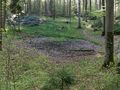
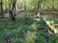
Back at the car I decided to try it a second time and reach the point from the north. On another way I could approach the hash up to 550 m, from there I walked on a forest path. About 130 m from the finish the trail ended and I found a small clearing which looked interesting to me. From there I walked about 70 m through the forest until I noticed the very soft ground. Two steps later my first shoe sank into the swamp, the second followed soon after. Only in socks I could save myself on safe ground and thought about my predicament and careless action. The shoes, about 3 m away from me, were still peeking out of the grass. Carefully I approached them, only climbing onto the tufts of grass. After I got my shoes back, I decided to bypass the swamp laterally. After I had overcome this obstacle, the hash point was reached and I was happy to have successfully completed my first expedition.
On the way back, my girlfriend, who had been waiting at the clearing, took pictures of my dirty shoes and my scratched legs. I decided to proceed more thoughtfully next time.
Photos
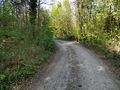
The way on my first try, near Grafrath
The mentioned clearing in the forest
Swamp in the forest
X marks the geohash

My trusty watch and the geohash

Screenshot proof

Dirty shoes and scratched legs


Ribbons
DominicTomato earned the Land geohash achievement
|