2020-04-24 42 -78
| Fri 24 Apr 2020 in 42,-78: 42.7086883, -78.5972992 geohashing.info google osm bing/os kml crox |
Contents
[hide]Location
On Cornwall Road next to Emery County Park in South Wales
Participants
- Pedalpusher
- Simon the dog
- Myka the dog
Expedition
It's been a very hectic week at the bank since I support one of the main systems we are using for the new Small Business Assoc. (SBA) loans the Government just passed into law for the second time. Banks REALLY don't like (and aren't really designed) to move this quickly, but our new system is, which is keeping us very competitive. But we are moving at break-neck speed and the weekend is very welcoming. When I saw the hashpoints in the morning, I thought this would be a great start to the weekend.
Seeing the Hash for today, I figured I could drive up to get the hashpoint without even getting out of the car and then I can take the dogs around the block and explore Emery Park which is a lot bigger than I thought. I was here as a little kid one winter when I was 10 or 11 and it's where I learned to ski. The County operates three small skiing hills (for free) and on the maps, I saw there was a trail close by that parking lot.
After work, I got the dogs ready and we headed over. Getting to the hash area was pretty easy and we found it just following the Phone GPS. Passing the hash on the wrong side of the road, I made a three point turn and pulled over next to the hash. On the Hashdroid app, I realized I drove slightly too far so I backed up but the phone GPS still wanted to put me on the other side of the road. But with a close enough reading, I got a couple pictures and we made another U-turn and headed into the park. Finding my way to the Ski area parking lot, I was surprised with how many people were out and about right at dinnertime. Instead of walking the trail, I decided to walk up and down the three skiing hills first since I didn't see anyone up that way. The dogs had a blast and even checked out the old Housing structure that had the T-Bar equipment that got people up the hill. They have replaced that system with a conveyor belt system that is much easier for newbies to use. I remember falling A LOT before I learned how to use the T-Bars.
After walking on each hill, we crossed the road toward the trail. Before getting to that trailhead, we checked out a big sign next to the woods which turned out to be the start of an Orienteering trail which led into a disc-golf course. This was much more interesting so we walked a few 'holes' before returning to the car and heading for home. Because I was in exploratory mode (and nothing really jumped out at me as overtly interesting), I didn't take any pictures at the park.
Photos
Made it.
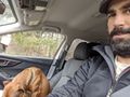
The dogs are as bad as kids sometimes when you are trying to pose them for a Picture.
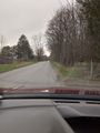
View West from the hash.


Ribbons
This user earned the Land geohash achievement
|