2020-05-25 42 -78
| Mon 25 May 2020 in 42,-78: 42.0864308, -78.7011811 geohashing.info google osm bing/os kml crox |
Contents
[hide]Location
Allegany State Park
Participants
- Pedalpusher
- Simon the dog
- Myka the dog
Expedition
This was definitely going to be off trail and possibly somewhat hard to get to. Looking over the Satellite pictures, I was sure I could park next to a bridge where a larger stream crossed the road and not too far away from the hash. I could then walk through the woods to what looked like a pipeline to get closer to the hash before heading uphill to find it.
Since today was Memorial Day, I had the day off and could plan for an afternoon hike. We got to Allegany around 15:30 and I was following a pickup truck down the road going slower than he needed to. Getting to the bridge, they pulled in to where I was going to park. Due to COVID-19, I decided to give them their space and made a u-turn just past the bridge, parking on the other side. As I was getting the dogs ready, they pulled back out and kept going down the road. I was a little annoyed as I would have rather liked to park in the shade, but whatever.
Since it was so hot, I wanted to give the dogs a chance to play in the water and cool off before we started our hike. There were some deeper pools just a little ways in from the road and they enjoyed a short swim. Continuing on, we made our way through the woods and found our way to what indeed was a pipeline (buried). It was easy walking along there but I wasn't quite sure where to start heading uphill. I knew I was looking for a creek and upon finding the first one, it felt like this might not be it yet. I was able to pick up enough signal on my phone to load the HashDroid app and was able to see there that I still wanted to keep going. Had I turn uphill here, I would have had to cross another ridge to get to the hash.
Confirming at the next creek, I put my phone away, fired up the GPS unit and started the trek uphill. It was not as steep as I expected and walking along this small creek was really nice. As we were heading uphill the creek was getting smaller and smaller. A little before we got to the hash area, the creek eventually disappeared, but the woods were still very open and it was an easy walk the rest of the way to the hash.
The GPS dance was short, but I was able to get a good reading and some pictures.
On the way down, I took a couple more pictures of some of the wildflowers that were blooming, but I didn't know what they were at the time. I was able to look them up to identify what I had found after I got home. Getting back to the pipeline, I had considered either extending my hike or maybe doing one of the shorter established trails. However, there were some very dark clouds moving in and at one point a couple rumbles of thunder. Happy to beat the rain to the car, we just headed for home instead.
Photos
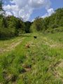
In the sun, walking down the pipeline toward the hash.
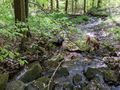
Finding our creek that we are going to walk up, the dogs found a couple pools to lay and play in.
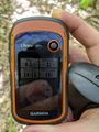
Made it.
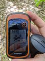
Accuracy.

The Hash-dogs pause their running around to get their picture taken.

Standard Stupid Grin.
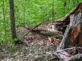
The hash landed near this large fallen tree.
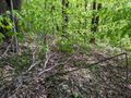
Another view of the Hash-woods.
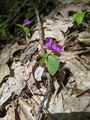
This was a really weird flower which is called a Fringed Polygala (also called Flowering Wintergreen).
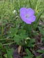
I originally thought this was Marshmallow, but looking it up to confirm, I found it was actually a Wild Geranium.
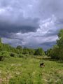
Getting back to the pipeline, we can see the storm rolling in with lots of rain and dark clouds. But we are in the sun and dry!


Ribbons
This user earned the Land geohash achievement
|