2020-05-29 53 9
| Fri 29 May 2020 in 53,9: 53.8137039, 9.9635534 geohashing.info google osm bing/os kml crox |
Location
in a restricted field/forest in northern Ulzburg, Henstedt-Ulzburg, Schleswig-Holstein
Participants
Expedition
Finally! The first geohash in my hometown since March 2019! Statistically, it lands here twice a year!
Another very unlikely coincidence: This hash was only 100 m from 2017-10-19 53 9, the last geohash in my hometown I didn't get as that was before I started, and third-last overall – which was located in the very same restricted area and which I retrohashed with Leidenfrost in June 2018.
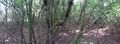
My mother had recently shown interest in my geohashing expeditions, so when the hash fell this near she was happy to come along. From the retrohash I knew the area was fenced, and the shortest route to the hash had a gate with a (very old and almost unreadable) sign that probably said there was no public access. When we arrived there after cycling about 4 km, this was still the case, and I advised that we try to access from the back where there was no fence as I did the last time. So we cycled another 2 km through Kaltenkirchen until we the path ended at a field. From there, we had to cross the field, which thankfully was easy because there was a walkable tractor wheel path through the ready-to-harvest barley, and we didn't damage any crops as we walked the 370 m. Next, we had to jump a small ditch and, after seeing the direct way was blocked by bosky vegetation, entered a planted forest, right next to where the retrohash had been. We passed a hideout probably built by children and walked another 200 m through the relatively dense trees. 35 m from the hash, I noticed the problem: There was a large fence separating the area where it lay from our forest, probably for keeping away animals. I found a spot where it was askew and climbable, but my mother decided to stay behind. I left my juggling balls with her, which I had intended to get another circus geohash achievement with, as my skills had drastically improved since last time.
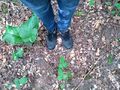
I stepped over the fence and had to navigate my way through a lot of branches, but when I finally reached the supposed location at the very edge of the forest, my phone said the hash was 20 m back. I walked along the edge and entered the forest at a different spot, but my location kept moving (the reception was terrible) and my phone wouldn't take screenshots again. After a long while, I managed to find a spot very near to the fence where my location matched the indicated hashpoint and took the ordinary pictures, but the coordinates said the point was still 20 m away where I'd originally been and where the satellite picture indicated. As my mother was waiting nearby, I decided not to go back because I had definitely been within 5 m of the correct location.
I stepped across the fence again and we went back through the forest and across the field, thinking it would've been wiser if we'd just entered from the gate in the south. We rode back through the commercial and industrial area, stopped at our local shopping centre to get some pencils and Döner for dinner (which was a challenge since my mother forgot to bring a face mask, so I had to wear my cardigan as a mask), then rode home after waiting way too long for our food. In total, we cycled 13 km.
Photos
proof 1

proof 2
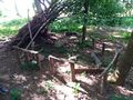
children's hideout
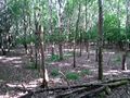
planted forest
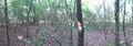
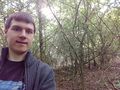
pano 1
pano 2
the hash, probably

π π π
basically the same


Achievements
Land geohash, Bicycle geohash, Drag-along achievement