2020-06-03 42 -78
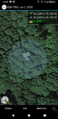
| Wed 3 Jun 2020 in 42,-78: 42.2693170, -78.7034301 geohashing.info google osm bing/os kml crox |
Contents
[hide]Location
In the woods by Holimont Ski Resort in Ellicottville
Participants
- Pedalpusher
- Simon the dog
- Myka the dog
Expedition
Looking this hashpoint over when it was published in the morning, I thought there was a decent shot at being able to get there. There is a road that leads up toward it and it looks like they are building houses in this area, but from the Satellite pictures, it still looks pretty empty of buildings. This is also pretty close to the edge of McCarty Hill State Forest and from Open Streetmaps, it looks like there are also trails that are pretty close to the hashpoint.
Things got a little hectic at work in the last hour, but fortunately, I was able to get out on time. With nothing else to do during this Pandemic, I figured we should give this one a shot. If there were unexpected houses (there was a pull-off right near the hash that looks like it maybe was going to be a driveway), I could go around the hill and try my luck from the State Forest side.
Getting the dogs' dinners ready, we drove down to Ellicottville and found the road by the hash. Driving down, I knew the trail close to the hash came back to hit the road near the main road and I saw that trailhead as I drove up the hill. Finding what now looks like where they were going to extend the road, I pulled off and parked. The dogs were pretty excited and we started up the (very steep) hill. We kind of circled around the hash, but I was able to navigate over to the trail that ran closest to the hash. Of course the hash was down a steep incline, but without too much trouble, we made our way over. This whole time walking, I had my GPS going, but it was having trouble picking up the satellites. And then when it did have a good signal, it was still saying that I was 0.2 miles from the hash even though I was practically standing next to it. Fortunately, the HashDroid App had a good signal on my phone and saved the day. I still had to do a wandering GPS Dance, but finally got a good reading and some pictures.
I still had plenty of daylight to hike around and thinking about it, I really didn't want to hike down the hill to the road only to have to walk back up the hill to the car. So we decided to go the other way and we followed the trails that ended up going right into the State Forest. We walked for about 20 minutes before turning around and heading back to the car.
While I was getting to the hash, I didn't see any Posted signs, but the trails definitely were part of the Holimont Cross-country Ski system so it felt a little weird. However, on the way toward the State Forest, in one section I saw a 'Semi-Posted' sign saying hunting was not permitted, but Hiking and Photography was quite all right, which made me feel better about not trespassing.
Photos
Made it!
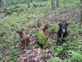
Dogs relaxing at the hash for a minute.

Standard Stupid Grin.
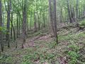
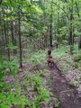
View of the Hash-woods, looking South.
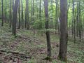
Another view from the hash, looking North.
After the hash, we hiked for a bit on the trails of the State Forest.
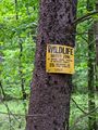
On the way back, I took a picture of the Permitted Access sign close to the area of the hash.


Ribbons
This user earned the Land geohash achievement
|