2020-06-14 42 -78
| Sun 14 Jun 2020 in 42,-78: 42.8967378, -78.2728862 geohashing.info google osm bing/os kml crox |
Contents
[hide]Location
In the Woods, behind the Alexander, NY Fire Hall
Participants
- Pedalpusher
- Simon the dog
- Myka the dog
Expedition
When the hashpoints were published, this looked reachable, but I wasn't exactly sure how to approach the hash. Being next to a couple athletic fields, I was hoping there was a Geocache close by which would tell me if it was publicly accessible. Using the 'Nearby Geochaches' option on the Geohashing.info site, I found a Cache right in the same section of woods. It even gave a suggestion of where to park before having to hike in the rest of the way.
The initial plan for today was going to be to take the dogs on a hike at Boston Forest County park and then leave them home when I went for this hash. However, I did some yard work all morning. I'm pulling out the grass between the sidewalk and the street in front of the house and transplanting it with Periwinkle. It's a lot of work and I'm doing it by hand so it's slowly getting completed in sections. Needing a break, I took a lazy lunch, relaxing on the couch. Realizing it was getting to be 14:00, I kind of ran out of time for Boston Forest. I then started looking at the map of the area and saw a State Forest close by that looked interesting with many trails running through it. I could just take the dogs with me and explore a new hiking area to make far better use of my time.
With a few things packed and directions queued up on my phone, we were on our way to Alexander, NY which is just North of Attica. Finding the Fire Hall without much trouble, I pulled into the parking lot and found my way to the back area where the athletic fields were. I parked on the grass near the baseball diamond and started walking in. Halfway through the field, Simon found a partially broken tennis ball and that just made his day. A hike and a 'new' toy? How can you go wrong!
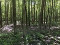
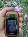
Getting to the end of the fields, we found the opening for the path that would take us right to the hash and cache. Since the Hash was closer, I stopped there first. It wasn't too far into the woods from the pipeline we were walking down. Doing a minor GPS dance, I got a good reading and some pictures. I then took a 'Distance to the Cache' reading for the Hash Collision event. Now I just need to find it.
Getting back to the path we headed to the cache for the next stop. Some of the logs for the cache said the coordinates were off a bit, so I started making sweeping and widening circles checking out possible locations. On the second sweep, I found it and signed the log. I took a second reading back to the cache to verify the distance and confirmed the Hash Collision Honorable Mention (There were too many trees in the way for direct line of sight).
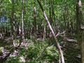
With everything documented, we headed back to the car and made our way to Carlton Hill State Forest/Multi-Use area. We hiked around for about 2 hours, found lots of trails and a couple ponds the dogs played and cooled off in. Exhausted but very happy on another successful adventure, we headed for home.
Photos
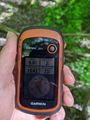
Made it to the hash.
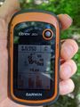
Accuracy.
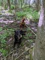
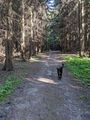
Dogs waiting for me at the hash.

Standard Stupid Grin.
View North from the Hash.
View South (and toward the pipeline we walked down).
From the Hash, the distance to the Cache.
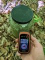
Located the Cache, and for verification, the distance back to the Hash.
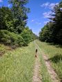
Walking back to the car on the Pipeline.
Exploring Carlton Hill afterwards.
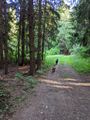
The trail goes through all different types of forest.


Ribbons
This user earned the Land geohash achievement
|
Pedalpusher earned the Hash collision honorable mention
|