2020-08-20 42 -78
| Thu 20 Aug 2020 in 42,-78: 42.0967666, -78.7149262 geohashing.info google osm bing/os kml crox |
Contents
[hide]Location
Allegany State Park (ASP) near the old Ski Hill
Participants
- Pedalpusher
- Simon the dog
- Myka the dog
Expedition
I always enjoy an expedition to ASP and while this was in the middle of the week, we still have enough daylight to drive down after work.
I was able to get a few things prepped at lunchtime so we were able to be on our way a little after 17:00 when I got done with work. The drive was uneventful and I arrived at our normal parking spot at the bottom of the Art Roscoe Ski Trails a bit after 18:00. With about an hour and a half of sunlight left, we started up the old Ski Hill. It's steep enough that I needed to pause about halfway up to catch my breath. Once we made it to the top, it mostly flattened out and there was a trail heading in sort of the right direction.
However, it wasn't long before I realized I needed to make my way into the woods because the trail was not going to get any closer. Working our way down the hill a bit, we came across a dry stream bed and it seemed the hash was pretty close to this so we used this as a clear path almost up to the hash. Doing a short GPS Dance, I was able to get a good reading and got a couple pictures.
Heading back up the hill, we found our way back to the unknown/unmarked trail. I had never been on this before but I was curious where it went. Despite not being marked, it was a well worn trail so I wasn't worried about losing it. We meandered through the woods and eventually saw a piece of roofing through the trees. I knew there was a lean-to on one of the trails that swung back this way and I realized I was approaching the Ridge Run trail. I've seen this connector trail from the Ski Area to the Cross Country Ski trails on Open Street Maps, but never saw a connecting trail when I was hiking Ridge Run and had no idea where it was. Turns out it was hiding behind the Lean-to! Cool, Trail confirmed!
Since we still had about an hour of light left, I set my timer for 20 minutes and walked down Ridge Run for a while before we turned around and headed back the way we came.
Photos
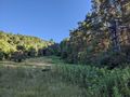
View of the Old Ski Hills, we are going to the top!
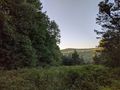
View across the valley from the top of the Ski Area.
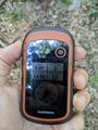
Made it!
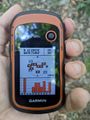
Accuracy.
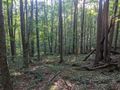
Woods from the hash looking West.
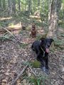
Hash-dogs waiting patiently.

Standard Stupid Grin.
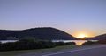
On the drive out, I got a picture of the sun setting in the valley overlooking the Red House Lake. The Admin Building and Bridge over the dam are also visible across the lake.


Ribbons
This user earned the Land geohash achievement
|