2020-08-22 42 -79
| Sat 22 Aug 2020 in 42,-79: 42.6678604, -79.0436170 geohashing.info google osm bing/os kml crox |
Contents
[hide]Location
In a field off Dennis Road near Wendt Beach
Participants
Expedition
I knew I wanted to go for a bike ride this weekend and when the hashpoints came out for this weekend, I thought this might be a nice ride to check out. I was pretty sure this would be posted and with the temps hotter than normal, I figured I would go in the morning when it was still relatively cool. Plus, I had a date in the afternoon anyway.
I got a later start than I wanted to, but I was on my way around 10:45 with directions in my head. I figured once I got close, I could turn on my phone map if needed. I was able to navigate my way down to Old Lakeshore Road and that led me right past Wendt Beach and toward the hash. Getting to the hash-road, I was very surprised to not see any posted signs along the field that contained the hash. However, there was a house near the corner of the field with the hash, and I felt weird about walking through the field and past the house. A little ways further, the woods enclosed the corner of the field and met the road. This was also not posted and there seemed to be a deer trail heading in the right direction to the field and hash.
Walking my bike in, I parked it next to a small tree before it got to the thick underbrush. Making my way carefully through the thick stuff, I mostly avoided the brambles and thorns. Finally getting clear, I was able to make my way around the field to the hashpoint. With very little GPS Dancing, I got a screenshot of the HashDroid and a few pictures of the area.
I had just as difficult of a time getting back to my bike, but once there, I was able to ride home without any issues.
Photos
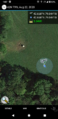
Made it!
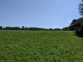
View East looking deeper into the field.
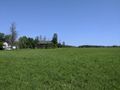
View North toward the house and an old falling-down barn.
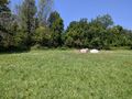
View West, back toward the road and where I left my bike.
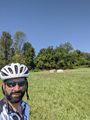
Stupid Grin.
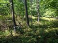
The Hash-bike waiting in the woods.
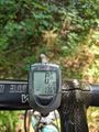
Distance to the hash.


Ribbons
This user earned the Land geohash achievement
|
Pedalpusher earned the Bicycle geohash achievement
|