2020-10-08 42 -78
| Thu 8 Oct 2020 in 42,-78: 42.0962798, -78.8574753 geohashing.info google osm bing/os kml crox |
Contents
[hide]Location
Next to the Allegany River near Allegany State Park
Participants
Expedition
You can see the Allegany River channel when you drive into Allegany State Park on the Quaker side, but I've never actually been over there. Seeing this hashpoint on the edge of the clearing next to the river, I thought it would be very interesting to check this out. As a bonus, it appears the hashpoint in the Dunkirk Graticule is just over the state line in PA which would give me another step toward the Reverse Regional Ribbon on a State/Province level. Now I just need to get to Canada once the borders open back up...
After work, I got the dogs set up with dinner, wrote out my directions and was on my way. One item to note on the drive down on the 219, over the Boston Hills, I saw a very ominous looking cloud and had to do a double-take. Was I looking at a large tornado? I got a quick picture out the window, but a little further on, I could see a bit around the hill and it turns out to be just a very weird looking cloud.
Back to the drive, I had initially thought I would be taking the 219 all the way to Allegany, and through Salamanca, so I could fill up my gas tank on the Native American Reservation (no taxes). However, my trip this evening would be taking approximately 3 hours so I was trying to go the fastest route possible which bypassed Salamanca. I knew I had plenty of gas to get to this hashpoint, but I didn't think I'd make it all the way to Pennsylvania and then up to Irving for cheap gas there about 90 miles away. Fortunately, right before I got on I-86 to backtrack slightly to the hash, I saw a gas station right there so I could stop on my way back out after the hash. I also wanted to get to the hash with as much light as possible remaining, just in case.
Taking the exit for Allegany, I was looking for an old abandoned road with a gate across it figuring that would be the best place to park and get off the road. Unfortunately, it was really overgrown and I didn't recognize it for what it was and drove right past. Checking my map, I realized I had driven too far and executed a U-Turn and ended up parking at a small vista overlooking a marshy area. I was a little concerned looking across the road as the ground dropped off sharply on the other side of the guard rail. Stepping over, I realized it wasn't actually that bad and carefully made my way down to more even ground.
My GPS said that I was about .25 miles away (~400 Meters) and the brush wasn't thick, but it still wasn't easy navigating my way toward the river. About halfway there, I looked down and realized I had a bunch of ticks crawling on me. Annoyed and grossed out, I paused to pull them off and crushed them, but one or two escaped. I continued on, periodically checking my legs for more.
Finally, I could see the forest opening up and I was nearing the edge by the hash. I was able to do a small GPS dance to get a good reading and got some pictures. Being so close to the river, but not being able to actually see it, I started walking out to the big berm in between. I should note that it has been extremely dry lately, and many of the local creeks were very dry or not running at all. Even the normally large Allegany River was very low. Walking across the cracked and dried mud of the flood-plain, I got to a small creek and crossed over a very deteriorated bridge onto the hill. Looking over, I still couldn't see the river it was so low. I considered continuing to walk over, but because it was getting close to sunset, I figured I better head back.
The way back was very similar to the way out. Pausing regularly to check for ticks and maintaining a course with the setting sun at my back. I didn't have any trouble finding my way back to the car and started on my way to Part 2: The Dunkirk Hash in PA.
Photos
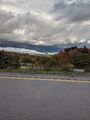
Strange looking cloud.
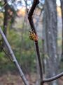
Starting into the woods, I ran into a very large spider web and looking down, I saw this guy on my arm. I put it on a branch and apologized.
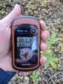
Perfect reading at the hash!
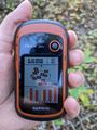
Accuracy.

Standard Stupid Grin.
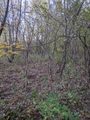
A view of the hash-woods (not sure which direction this was).
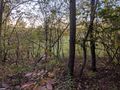
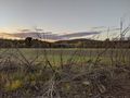
At the edge of the woods, a view west from the hash, toward the river.
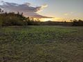
Was getting a very nice sunset this evening.
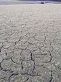
The dried and cracking mud of the floodplain near the abandoned bridge.
On the little hill across the creek, a view toward the highway and the bridge over the river.


Ribbons
This user earned the Land geohash achievement
|