2020-10-30 42 -78
| Fri 30 Oct 2020 in 42,-78: 42.4285266, -78.8894542 geohashing.info google osm bing/os kml crox |
Contents
[hide]Location
Zoar Valley, just off Forty Road in the woods
Participants
- Pedalpusher
- Simon the dog
- Myka the dog
Expedition
I had taken a random half day as I needed to use my Time Off by the end of the year or risk losing it. When the hashpoint was published, I saw this would be perfect to go get in the afternoon. I wouldn't even have to rush as I had plans later in the evening with my girlfriend.
Work was of course busy and threatened to keep me later than I wanted, but I was able to wrap up my responsibilities with a few minutes to spare and was able to shut down the computer right around noon. I made a sandwich for myself and relaxed while I watched some TV and then was on my way around 14:00 with the dogs excited to go exploring. I considered leaving them at home because Zoar is notorious for steep, unstable cliffs, but the topo map on Google indicated this side was not as steep or 'cliffy'.
Using my phone to guide us, we were able to find our way with relative ease, although the last couple miles of road was rough, narrow and very twisty. I did find a really awesome looking waterfall, but figured I could stop on the way back to grab a picture. It would be easier to pull off as the other side had very wide shoulders at the turn right after the falls.
I knew the Hash-road was a Dead End, but I couldn't really tell exactly where the road ended relative to the Hash. It looked like there were a couple pull-offs right near there, but as I drove down the road, these were marked with 'No Parking' signs. Fortunately, the road kept going and I was able to park at the end, near the barriers. This would also allow me to walk away from the ravine and the dogs could stay off leash without worry about any cliffs for a while.
Making our way back up the road, it was an easy walk into the mostly clear woods for the GPS Dance. Getting a good reading, I got my pictures and we headed back to the end of the road to explore a bit more before heading back home. There was supposed to be a trail and it turns out it just follows the old, abandoned roadway down to the river but ends at the foundation of the old bridge that either got taken out or was washed away at some point. I could see the Pathway and park area on the other side which had a similar trail setup, but was a bit more built up than where we were. At the end of the path, the drop-off was significant so I had to keep the dogs away from it. There were other sections that we could have navigated down earlier in the trail to get closer to the water, but I didn't feel like skidding and scrambling down and up the steep hillside to do it. I should also mention that when I got down close enough to see the water, I was confused and thought that it was flowing the wrong way. Looking at Google Maps, I found we weren't actually on the main river and this was just another large tributary before it joined up.
With nowhere else to go, we headed back up to the car and headed for home. I met up with my girlfriend in the city for dinner and a Ghost Hunting tour at one of Buffalo's many Grain Elevator 'cities'. Ghost Hunting is...weird...
Photos
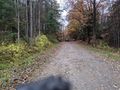
Looking back at the Hash-mobile, after starting up the road toward the hash.
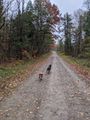
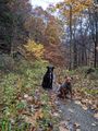
The dogs are enjoying themselves on the open road.
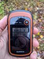
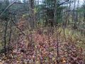
Made it to the hash!
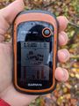
Accuracy.
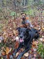
Hash-dogs hanging at the hash.
View North toward the road.

Standard Stupid Grin.
Starting toward the car, a look back at the hash.
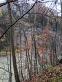
About halfway down the trail, the dogs posed nicely on the trail.
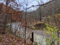
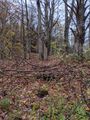
At the bottom of the trail, you can see where the old bridge used to be...
And the steep cliffs on the other side too.
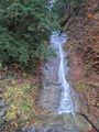
Stopping to take a picture of the awesome waterfall on the way home.


Ribbons
This user earned the Land geohash achievement
|