2020-12-11 42 -78
| Fri 11 Dec 2020 in 42,-78: 42.6512648, -78.5495222 geohashing.info google osm bing/os kml crox |
Contents
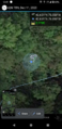
[hide]Location
Across Route 16 from the Holland Middle School
Participants
Expedition
This had to be one of the most frustrating expeditions I've gone on, but I have to say it looked very promising when the hashes were published in the morning. I had another hash I ended up skipping last week because it gets dark before 17:00 now and I didn't want to let another hash get away. I decided I would go at lunchtime as this was just about a half hour drive away. Looking at the satellite pictures, I figured I could park in the empty construction storage lot next to the woods by the hash. I did wonder what I would do if there was a cop sitting in there watching traffic when I got there, but figured I'd cross that bridge if I needed to.
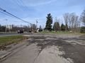
I had a call wrap up a few minutes past noon so I was a little late starting my journey to Holland, NY, but I had the trusty phone GPS guiding my way on Google Maps. Unfortunately, I got stuck behind a slow driver going down the hills when I was about 5 minutes away. Not a big deal, but getting to the end of the road, I was looking into where I wanted to park and sure enough, there was a Sheriff vehicle sitting WAY back watching for speeders. Not wanting to get the Police Geohash, I decided to park near the cemetery which was next to the clearing for this property and just walk over to the hash-woods.
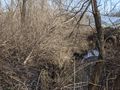
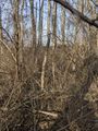
I contemplated walking around the other side, but figured with no posted signs on the property or the wooded area, I'd just save myself some time and walk right over. The cop didn't seem to care as I made my way down the slope, although I did notice right before I stepped out of sight that they were leaving the area, possibly to go get someone. They didn't come over to bother me at all anyway. Getting to the bottom of the small gully area, I was dismayed to see the very thick vegetation which was mostly made up of large brambles and thorns. I started carefully making my way through hoping to get quickly to the hash following the HashDroid app on my phone, but either I didn't have a great signal or just couldn't easily tell which way to go, but it felt like I wandered all over the area without getting closer than 25 feet. Finally, looking at the map carefully again and moving around, I was able to get a good reading right next to the creek, but it took about 20 minutes of working my way around down there.
Satisfied with the reading, I got my pictures and made my way back to the car eating a Reese's peanut butter tree. On the way home, I got stuck behind another slow (old man) driver, this time for a long time as they meandered over the winding roads going 20 MPH when the speed limit was 45...very frustrating. I've got some time off to use up before the end of the year so hopefully I can squeeze in a few more expeditions this month.
Photos
Finally made it.

View up the Creek toward the road.
View the other way down the creek.
View toward the open lot where I walked in.

Standard Stupid Grin.
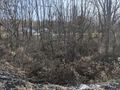
View of the Hash Area after I successfully escaped.
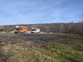
View of the open lot where it looks like the town stores equipment and road ingredients like gravel and such.
View of the hash-mobile


Ribbons
This user earned the Land geohash achievement
|