2021-01-02 62 29
| Sat 2 Jan 2021 in 62,29: 62.5991707, 29.8527438 geohashing.info google osm bing/os kml crox |
Location
Near a house and highway 74 in Kissamäki, Joensuu.
The point on a topographic map: [1]
Participants
Expedition
I have been unlucky with geohash locations lately, but today I was finally able to reach one. Most have ended up being too far from my home or in water which has not yet been frozen thickly enough to be safe to traverse. This one was in an easy location, and the conditions were manageable: temperature 0 °C and sleeting slightly.
I cycled along the roads of Karsikko and highway 74 to the intersection of the house, and I left the bicycle at the edge of the forest. There was a new cleared line in the forest that did not exist on any map or aerial photo, and I could follow it towards the hashpoint. I only had to walk the last twenty metres in deep snow which was not really deep, maybe twenty centimetres at most. I took a few pictures and left because I was running out of daylight.
I was back at home at about 3 pm when it was already slowly getting darker. The sun had already set at 14:31. I could have gone to the geohash at the Saturday meetup time at 4 pm, but it would have been pitch-black by then, and I would not have been able to see much or take any presentable photos.
Photos
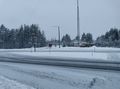
Iiksenportti road near Kissamäki.
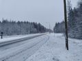
Highway 74 near Kissamäki.
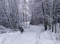
Where I left the bicycle, about 80 metres to go.
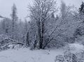
The hashpoint was at this tree, which I believe is a grey alder (Alnus incana).
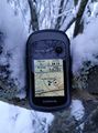
Proof of location.
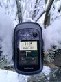
Proof of date and time, quite blurry but legible enough.

Selfie at the hashpoint.


Achievements
Kripakko earned the Land geohash achievement
|
Kripakko earned the Bicycle geohash achievement
|