2021-01-30 43 -78
| Sat 30 Jan 2021 in 43,-78: 43.1495601, -78.3879116 geohashing.info google osm bing/os kml crox |
Contents
[hide]Location
Near the Northern border of the Iroquois National Wildlife Refuge
Participants
- Pedalpusher
- Simon the dog
Expedition
I met J early in the morning at the car dealership with the dogs; she was taking her car in for some maintenance. We then drove over to the Lockport Nature Trails to continue on our Winter Hiking Challenge. This was the plan all along, but it worked out even better since this Hash was close enough for a detour after our hike. I was pleasantly surprised at the amount of land and intricate trail system throughout. It was a pretty nice hike which even featured a frozen waterfall in the back.
After we got back to the car from hiking, I put in the coordinates for the Geohash and we were on our way over. On the final road, I saw we had a decent shoulder to pull off and park, but was a bit concerned as it was a busy road. I decided to pull off further leaving just the driver side wheels on the road and the other side in the snow. I figured with my Subaru, I wouldn't have any trouble getting back out. J decided she was going to stay in the car and so I left Myka there too where the could both stay warm.
Simon, happy as ever to go on an adventure, crossed the road with me to the field next to the hash. Once there, I let him off leash and he happily bounded through the snow. Getting to the hash area, I could see the large flat area where the small pond was but as I stepped into the taller grass, my feet shot through the snow and thin layer of ice into some water. Turns out there was a small hidden creek/ditch where water ran through. Fortunately, the water wasn't deep enough to go over my boots, but I could definitely feel the cold. Getting past that section in about 3 big steps, I was back on more solid ground but was now being extra careful. Approaching what I thought was the hash at the edge of the ice over the pond, I was unhappy to see I was still reading over 20 feet away and not within the Circle of Uncertainty. Uh-oh. I really didn't want to go out onto the ice as I didn't have anything to check the thickness (although it supported Simon just fine) and had no idea how deep it was.
Walking around the pond, I was then able to see over the rise on the other side confirming that this was indeed the pond next to the hash. I went back to the hash area again to kind of edge out, but suddenly, the reading jumped close and I was able to get a screenshot of being within 2 feet! Taking a couple more pictures of the area, we made our way back to the car and headed for J's apartment since her car wasn't quite ready yet. On the way, J ordered us lunch from Panera which we took back to her apartment to enjoy.
Photos
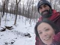
Found the (now Frozen) Waterfall from the Summer Hiking Challenge.
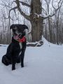
Simon posing at the Winter Challenge Landmark.
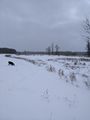
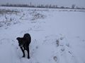
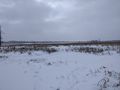
Walking along the edge of the field, a view of the Hash area.
Really happy to make it at the very edge of the iced over pond.
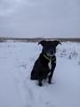
Simon patiently waiting at the Hash.
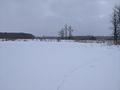
View East, looking over the pond. You can see where I walked along the edge earlier.
View West, back toward the road and car.
View South.
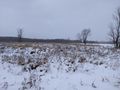
View North toward the field.

Cold, Stupid Grin today...

because it was a windy Frozen Geohash.


Ribbons
This user earned the Land geohash achievement
|
Pedalpusher earned the Frozen Geohash Achievement
|