2021-03-19 53 9
| Fri 19 Mar 2021 in 53,9: 53.9864402, 9.8848260 geohashing.info google osm bing/os kml crox |
Location
on a giant field in Hardebek, Schleswig-Holstein
Participants
Expedition
I was on the fence about doing this hash, because it meant I had to hurriedly cycle 40 minutes in the cold, but decided to go for it because of my new commitment to attempt all sub-2h geohashes, and it was only a little over two hours.
So I took the A1 train to Wiemersdorf and then cycled 6.5 km through the countryside. I only had 48 minutes from train arrival to departure, and according to Google that was exactly the time I needed to get to and from the hash, including walking, so I had to rush to spend a few minutes at the hash. It lay near the far edge of a giant field. Fortunately, I could walk 330 m across a non-cultivated adjecent meadow and then had to walk only 35 m onto the muddy low-grown fertilised field of the hashpoint. I took the photos and then jogged back, noticing at my bike that I only had one minute more time than I'd need for the distance, so I upped my speed significantly on the way back. Past halfway, I checked again and Google said I was still only one minute ahead (and I didn't want to arrive at the last second), so I dismissed slowing down, expecting to arrive 2 minutes early. But even though I slowed down at the end and lost a minute, I was still more than 3 minutes early – screw you, Google Maps time estimates! I didn't have to exhaust myself! The train arrived a little late and took me home.
Photos


coords

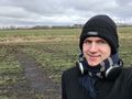
proof
π π π
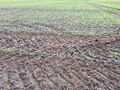
boring hashfield
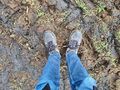
the hash
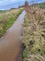
nearby river


Achievements
Land geohash, Bicycle geohash, Public transport geohash