2021-03-30 53 10
| Tue 30 Mar 2021 in 53,10: 53.8228384, 10.0353213 geohashing.info google osm bing/os kml crox |
Location
on a huge meadow in Kisdorf, Schleswig-Holstein
Participants
Expedition
I'm getting really lucky with the geohashes – this is my seventh hash within three weeks, and the 16th of the year! At this pace, I might average a hash a week this year, but it seems unlikely to continue this way.
I cycled 7.5 km to this hash, severely overequipped against cold as it was over 20°C for the first time this year, incredibly warm for March. The ride went quite steadily uphill, and on my way I stopped in Kisdorf's crow forest, where hundreds of crows nest in only a few trees. I reached the giant meadow on which the hashpoint was located, cycled along it and parked my bike in the adjacent forest to save some walking distance, though I still had to cross more than 200 m to get to the coordinates. But I was eased that nothing grew on the field except for grass. I found the spot, took photos and walked back. I decided to visit the Rathkrügen, at 91 m one of southern Schleswig-Holstein's highest hills (according to peakvisor the seventh-most prominent peak in the state and the highest point for 32.5 km around up to Hamburg's Baursberg). It was located just 770 m southeast of the hash, 180 m from the street I came. There, I took a panorama, but expectedly, the view wasn't really special. On my way back, I got to continually roll downhill.
Photos


coords

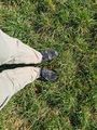
proof
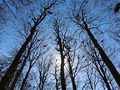
the crow forest
the cacophony of hundreds of screaming birds
the hash
π π π
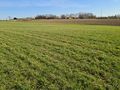
hashfield
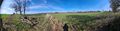
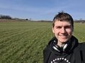
the breathtaking view from southern Schleswig-Holstein's highest mountain


Achievements
Land geohash, Bicycle geohash