2021-03-31 48 7
| Wed 31 Mar 2021 in 48,7: 48.2978890, 7.4449001 geohashing.info google osm bing/os kml crox |
Location
In an orchard a meadow near Scherwiller.
Participants
Plans
Baarde is going to take his bicycle and ride there in the afternoon. He expects to reach the hashpoint around 15:00.
Expedition
The hashpoint was located near Scherwiller, a small wine-producing town along the EuroVelo 5 (Again! What a great week for geohashing).
According to satellite imagery, the geohash was supposed to be in the middle of an orchard. However, the coordinates were completely tree-less.
After recording proof, I turned westwards and made a 20 km loop through the Vosges mountains before stopping on a small hill below the Ramstein and Ortenbourg, two ruined castles commanding Scherwiller and the entrance to the Val de Villé and Val d'Argent valleys.
On my way back, I suddenly noticed a strange noise and vibrations coming from my front wheel. Upon inspection I discovered a tear in the tire bead, which has caused the tire to partially dislodge from the rim and form a bulge that was rubbing against the break pad. I was quite annoyed as I hadn't any spare tire on me and I was 9000 wheel revolutions (about 20 km) away from home. However, after decreasing the air pressure in the tire, the bulge subsided and I was able to reach home without further incident.
Photos
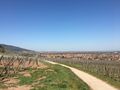
Cycling through the vineyards
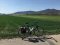
Where's the orchard?
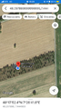
Coordinates reached
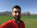
Stupid grin
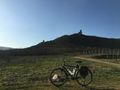
The Ramstein and Ortenbourg castles
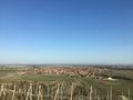
Scherwiller
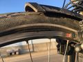
That's not supposed to happen


Achievements
Baarde earned the Land geohash achievement
|
Baarde earned the Bicycle geohash achievement
|
Baarde earned the Hashcard achievement
|