2021-04-06 -36 146

| Tue 6 Apr 2021 in -36,146: -36.3998146, 146.7334492 geohashing.info google osm bing/os kml crox |
Location
In bushland near Beechworth.
Participants
Plans
I had a long drive back from Mt Hotham to Melbourne, so looked to spice it up a bit. My quick glance at the geohashing map showed a point in some bush, so that was about as much planning as I did until I drove to Stanley. I was figuring I'd do some mountain biking to get to the point.
Expedition
Around Stanley I stopped to figure out an actual plan, but fell into a Technological Nightmare. Somehow, between my two phones, very poor mobile reception, badly configured maps, apps that didn't talk to each other well, and a general lack of pre-planning, I spent a very frustrating half an hour trying to just get the damn geohash point on a map that showed the nearby 4WD tracks.
I then thought I'd see how close I could drive. A couple of tracks turned out to private driveways, until I found one that went into the State Park. The track got worse and worse, bringing back memories of the time I cracked a sump on my mum's car on a remote 4WD track. So, I took it very, very gently.
Eventually I found a good place to stop and pondered my options. I was now a bit too close to ride, really - less than 2km by track to the point that I would have to bush bash. I could also see that it was going to be a 500m bush bash - eep!
I gathered up an insane amount of supplies into my backpack, but then realised I was a bit short on water - less than a litre. So I threw in a couple of tomatoes for good measure, and headed off on foot.
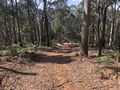
It was very nice, relaxing walking. Pleasant weather, no trail bikes. Before long I got to the bush-bash point.
Fortunately the scrub was pretty open. At times I followed wombat tracks. Sometimes the scrub opened up completely making very easy cross-country walking, as I descended down and down towards the hash. As usual, I pondered if anyone had been here before. There were marks of trees cut down many years earlier, but no more recent signs of human activity.
The hash itself was at a big log in a kind of clearing. I took the photos, then wandered back up the hill, by a different route. By some strange coincidence (I wasn't looking at my map), I hit the track at the exact same point I entered.
I then took a longer route along the track back to my car, feeling pretty pleased with a successful bush bash hash!
Tracklog
Photos
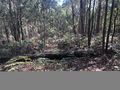
Bushland
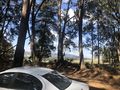
Car at the start
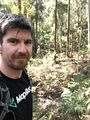
At the hash
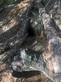
A wombat hole
Down a steep track


