2021-04-10 62 29
| Sat 10 Apr 2021 in 62,29: 62.6401767, 29.8717236 geohashing.info google osm bing/os kml crox |
Location
At the northern side of the Utranharju ridge.
The point on a topographic map: [11]
Participants
Expedition
Finally, after a long while, I got a hashpoint that I could visit conveniently. We are slowly approaching the end of the snowy season, but as usual there has been so much snowfall during the winter that it will probably last until early May or so. Most hashpoints have ended up too far and often hundreds or even thousands of metres from the nearest open roads, so visiting them without proper equipment and determination has not been not practical. This one I could visit by cycling along the paved road (Jokirannantie), walking along the maintenance road of the mast on the ridge, and traversing about a hundred metres of snowy forest.
I went and cycled to the beginning of the maintenance road. The paved roads have long been clear of ice and snow, so they were easy to traverse, but the little maintained forest road was snowy at some places and muddy elsewhere, suffering from rasputitsa. It was too difficult for my bicycle tyres, so I left the bicycle at the beginning of it and continued on foot. I walked first to the top of the ridge where the skiing track from the town goes. I could have skied here too, but the track has already been left unmaintained, and indeed it was in quite a bad condition: maybe theoretically traversable but practically not enjoyable and potentially unsafe. The snow is melting and revealing debris and other hazards underneath.
I then backed to a point where I would enter the forest. I found the place where a trail goes in the summer – not that it really helped me, but I could easily follow it because I saw some very old footprints on it. The depth of the snow was 40 cm in the worst places plus however much was compressed under my feet. The shafts of my boots were too short and were soon filled with snow, but I did not care. It was not immediately too cold, and I could empty them after I got back on the road. The trail went along a small crest (orienteers would call this a spur), and the hashpoint was a few metres off the trail. I took a few pictures and carried on. I was at the hashpoint at 4 pm, making this a Saturday meetup, though I unsurprisingly did not meet anyone there.
I walked to the end of the crest and got a nice view down the ridgeside. The maintenance road was ten metres below me, and I wanted to get back there. While I could not have climbed the slope without much effort, I could descend it fast by buttsliding. The surface of the snow was strong enough to support me that way but not if I was standing on my feet. I got down, emptied my boots of snow, walked back to the bicycle and cycled back to Joensuu. I ended up cycling 13.5 km and walking 1.2 km during the trip.
Photos
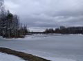
The Pielisjoki river near the Utra islands. [1]
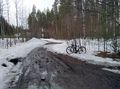
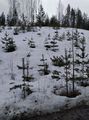
Where I parked the bicycle, 290 metres to go as the crow flies. [2]
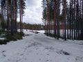
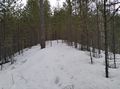
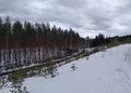
How the skiing track looks now, not nice. [3]
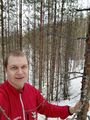
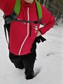
Selfie at the hashpoint. [4]
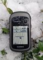
Proof of location. [5]
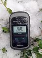
Proof of date. [6]
My footprints in the snow, looking back to the hashpoint. [7]
Standing almost knee-deep in the snow. [8]
View down the extreme ridgeside, you can see the muddy road up close and the paved road in the distance. [9]
View back up to where I just came from with a visible buttslide track in the snow. [10]


Achievements
Kripakko earned the Land geohash achievement
|
Kripakko earned the Bicycle geohash achievement
|