2021-04-19 42 -78
| Mon 19 Apr 2021 in 42,-78: 42.5183260, -78.3290832 geohashing.info google osm bing/os kml crox |
Location
End of a Driveway on North Road in Freedom, NY
Participants
- Pedalpusher
- Simon the dog
- Myka the dog
Expedition
Looking at the map for this hash, I was thinking I could pull into this driveway 'to turn around' and pick up the Geohash, especially since it didn't look like the house for this driveway was very close. Not wanting to just drive out there to turn around and go home, I zoomed out and saw there was a State Forest just down the road. This would work as I could then take the dogs for a hike and explore a new area too! It didn't look like there were any trails on the map, but there was a closed forest road we could walk down at least. I've found that there is usually an unofficial trail at the end of these state roads too so maybe we'd get lucky and be able to continue walking. Otherwise, we could just walk the road twice if it came to that.
After work, I got the dogs ready and got some food for them. Being Monday, I had my usual leftover pizza in the fridge that I could take and eat on the way. With the phone GPS guiding us along, we found the hash-road with no trouble, but nearly drove past the driveway. Had to back up just a little to pull in while I had the Hashdroid app running. Turned out I had to pull in a little more than a full car length, but was able to get a good reading and some quick pictures before pulling back out. Satisfied with the success, we headed back to Washburn Road and to the State Forest.
Finding a very large parking area, we pulled in and the dogs were excited to explore a new place. I set my alarm for half way to sunset to insure we would have light to get back by, and it was easy walking down the forest road. I did notice there were a bunch of trees that were marked (most likely for logging soon), and some ATV trails that came out to the road on occasion. I figured if nothing else, we could explore those if we didn't find anything at the end to walk down.
The end of the road was a big wide turn around, but like earlier, there was a path leading in. It looked like another old logging trail and the woods were pretty open back here. Seems like this section was logged a couple years earlier so they were doing another section closer to the road this time. The trail split off a couple times, but we tried to go straight each time (so as not to get lost). Eventually, the trail we were following just disappeared into the surrounding brush. Still with plenty of time on the clock, we headed back and turned down one of the side trails that seemed to be heading to a section of Pine trees. I'm glad I picked this trail because shortly after entering the pines, I found a primitive campsite with a fire circle and a little past that was some ruins which I believe was the well indicated on the website: In the 1930's, the Lost Nation Civilian Conservation Corps (CCC) camp, S-126, was located on this State Forest along Lost Nation Road. Other than a small concrete building foundation, an artesian well and the Norway spruce trees lining the road, little evidence of the camp remains.
Continuing further, we walked along a ravine for a bit and then the trail started to get mushy and swampy. Since it was almost getting time to turn around anyway, we headed back a few minutes early. Back on the forest road, we made it back to the car with plenty of daylight left and the dogs got to eat their dinner.
A note on this State Forest's name: The forest is named after the fabled "Lost Nation," a resident tribe of Native Americans who unexpectedly disappeared from the area without a trace.
I should also note that this is (after a year to be sure) a Last Man Standing and a new Centicule for me in the Buffalo Graticule; All-in-all, a pretty cool way to spend the evening!
Photos
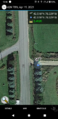
Made it!
View North from the hash.

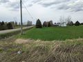
Pulling out of the driveway and to the side of the road, the Stupid Grins. The dogs are a little restless in the car making pictures difficult.
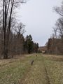
A view back to the hash (next to the pine trees on the right side).
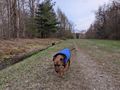
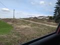
Getting to the State Forest, playing on the road (and Simon in the ditch getting some water).
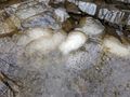
Getting into the woods, nearly every pool and puddle had these egg sacks in them. Massive, about the size of your fist. According to this website, they are Spotted Salamander Eggs. Cool!
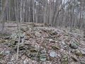
Back in the woods, the abandoned (and filled in) well (I think).
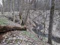
A view of the ravine on the way back.
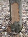
Near the ravine, there was, what I believe, to be evidence of Porcupines. I know they eat bark of trees and the soft new twigs that grow in the spring.
Another view of the forest road on the way back to the car.


Ribbons
This user earned the Land geohash achievement
|
Pedalpusher earned the Last man standing achievement
|
Expeditions and Plans
| 2021-04-19 | ||
|---|---|---|
| Buffalo, New York | Pedalpusher, Simon the dog, Myka the dog | End of a Driveway on North Road in Freedom, NY |